Argentré-du-Plessis (Argentré-du-Plessis)

- commune in Ille-et-Vilaine, France
- Country:

- Postal Code: 35370
- Coordinates: 48° 3' 26" N, 1° 9' 14" E


- GPS tracks (wikiloc): [Link]
- Area: 41.46 sq km
- Population: 4294
- Web site: http://www.argentre-du-plessis.fr
- Wikipedia en: wiki(en)
- Wikipedia: wiki(fr)
- Wikidata storage: Wikidata: Q635305
- Wikipedia Commons Category: [Link]
- Freebase ID: [/m/03c8l4m]
- Freebase ID: [/m/03c8l4m]
- GeoNames ID: Alt: [3037016]
- GeoNames ID: Alt: [3037016]
- SIREN number: [213500069]
- SIREN number: [213500069]
- BnF ID: [15256950q]
- BnF ID: [15256950q]
- VIAF ID: Alt: [137190202]
- VIAF ID: Alt: [137190202]
- OSM relation ID: [106681]
- OSM relation ID: [106681]
- Library of Congress authority ID: Alt: [n79006168]
- Library of Congress authority ID: Alt: [n79006168]
- INSEE municipality code: 35006
- INSEE municipality code: 35006
Shares border with regions:


Gennes-sur-Seiche
- commune in Ille-et-Vilaine, France
- Country:
- Postal Code: 35370
- Coordinates: 47° 59' 17" N, 1° 7' 26" E
- GPS tracks (wikiloc): [Link]
- Area: 18.5 sq km
- Population: 930
- Web site: [Link]

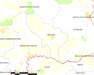
Brielles
- commune in Ille-et-Vilaine, France
- Country:
- Postal Code: 35370
- Coordinates: 48° 0' 31" N, 1° 5' 26" E
- GPS tracks (wikiloc): [Link]
- Area: 11.4 sq km
- Population: 717
- Web site: [Link]

Le Pertre
- commune in Ille-et-Vilaine, France
- Country:
- Postal Code: 35370
- Coordinates: 48° 2' 5" N, 1° 2' 14" E
- GPS tracks (wikiloc): [Link]
- Area: 43.63 sq km
- Population: 1390
- Web site: [Link]


Étrelles
- commune in Ille-et-Vilaine, France
- Country:
- Postal Code: 35370
- Coordinates: 48° 3' 37" N, 1° 11' 37" E
- GPS tracks (wikiloc): [Link]
- Area: 27.17 sq km
- Population: 2545
- Web site: [Link]


Saint-Germain-du-Pinel
- commune in Ille-et-Vilaine, France
- Country:
- Postal Code: 35370
- Coordinates: 48° 0' 44" N, 1° 9' 58" E
- GPS tracks (wikiloc): [Link]
- Area: 11.3 sq km
- Population: 913

Erbrée
- commune in Ille-et-Vilaine, France
- Country:
- Postal Code: 35500
- Coordinates: 48° 5' 56" N, 1° 7' 28" E
- GPS tracks (wikiloc): [Link]
- Area: 35.52 sq km
- Population: 1677
- Web site: [Link]


Mondevert
- commune in Ille-et-Vilaine, France
- Country:
- Postal Code: 35370
- Coordinates: 48° 5' 3" N, 1° 5' 56" E
- GPS tracks (wikiloc): [Link]
- Area: 5.02 sq km
- Population: 811

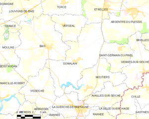
Domalain
- commune in Ille-et-Vilaine, France
- Country:
- Postal Code: 35680
- Coordinates: 47° 59' 46" N, 1° 14' 30" E
- GPS tracks (wikiloc): [Link]
- Area: 33.54 sq km
- Population: 1985