Artonges (Artonges)
- former commune in Aisne, France
- Country:

- Postal Code: 02330
- Coordinates: 48° 55' 45" N, 3° 33' 10" E


- GPS tracks (wikiloc): [Link]
- Area: 13.12 sq km
- Population: 177
- Wikipedia en: wiki(en)
- Wikipedia: wiki(fr)
- Wikidata storage: Wikidata: Q677945
- Wikipedia Commons Category: [Link]
- Freebase ID: [/m/03m4ky5]
- Freebase ID: [/m/03m4ky5]
- GeoNames ID: Alt: [6446442]
- GeoNames ID: Alt: [6446442]
- INSEE municipality code: 02026
- INSEE municipality code: 02026
Shares border with regions:

Pargny-la-Dhuys
- commune in Aisne, France
- Country:
- Postal Code: 02330
- Coordinates: 48° 57' 12" N, 3° 33' 15" E
- GPS tracks (wikiloc): [Link]
- Area: 12.66 sq km
- Population: 177


Corrobert
- commune in Marne, France
- Country:
- Postal Code: 51210
- Coordinates: 48° 54' 56" N, 3° 36' 17" E
- GPS tracks (wikiloc): [Link]
- Area: 14.26 sq km
- Population: 201

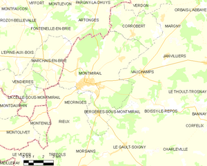
Montmirail
- commune in Marne, France
- Country:
- Postal Code: 51210
- Coordinates: 48° 52' 15" N, 3° 32' 26" E
- GPS tracks (wikiloc): [Link]
- Area: 48.82 sq km
- Population: 3643
- Web site: [Link]
Fontenelle-en-Brie
- former commune in Aisne, France
- Country:
- Postal Code: 02540
- Coordinates: 48° 55' 7" N, 3° 28' 41" E
- GPS tracks (wikiloc): [Link]
- Area: 8.47 sq km
- Population: 210
Montlevon
- commune in Aisne, France
- Country:
- Postal Code: 02330
- Coordinates: 48° 57' 57" N, 3° 32' 21" E
- GPS tracks (wikiloc): [Link]
- Area: 22.65 sq km
- Population: 294