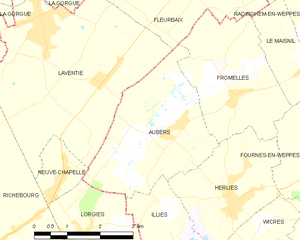
Aubers (Aubers)
- commune in Nord, France
- Country:

- Postal Code: 59249
- Coordinates: 50° 35' 43" N, 2° 49' 30" E


- GPS tracks (wikiloc): [Link]
- Area: 10.14 sq km
- Population: 1586
- Web site: http://www.aubers.fr/
- Wikipedia en: wiki(en)
- Wikipedia: wiki(fr)
- Wikidata storage: Wikidata: Q664635
- Wikipedia Commons Category: [Link]
- Freebase ID: [/m/03h2ytg]
- Freebase ID: [/m/03h2ytg]
- GeoNames ID: Alt: [3036394]
- GeoNames ID: Alt: [3036394]
- SIREN number: [215900259]
- SIREN number: [215900259]
- BnF ID: [15266603k]
- BnF ID: [15266603k]
- VIAF ID: Alt: [124772590]
- VIAF ID: Alt: [124772590]
- GND ID: Alt: [4324534-1]
- GND ID: Alt: [4324534-1]
- Library of Congress authority ID: Alt: [nr94025319]
- Library of Congress authority ID: Alt: [nr94025319]
- INSEE municipality code: 59025
- INSEE municipality code: 59025
Shares border with regions:


Fleurbaix
- commune in Pas-de-Calais, France
- Country:

- Postal Code: 62840
- Coordinates: 50° 39' 8" N, 2° 49' 58" E


- GPS tracks (wikiloc): [Link]
- Area: 12.86 sq km
- Population: 2653
- Web site: [Link]


Neuve-Chapelle
- commune in Pas-de-Calais, France
- Country:

- Postal Code: 62840
- Coordinates: 50° 35' 2" N, 2° 46' 49" E


- GPS tracks (wikiloc): [Link]
- Area: 1.86 sq km
- Population: 1394


Lorgies
- commune in Pas-de-Calais, France
- Country:

- Postal Code: 62840
- Coordinates: 50° 34' 5" N, 2° 47' 26" E


- GPS tracks (wikiloc): [Link]
- Area: 6.84 sq km
- Population: 1585
- Web site: [Link]


Illies
- commune in Nord, France
- Country:

- Postal Code: 59480
- Coordinates: 50° 33' 41" N, 2° 49' 52" E


- GPS tracks (wikiloc): [Link]
- Area: 7.91 sq km
- Population: 1469


Laventie
- commune in Pas-de-Calais, France
- Country:

- Postal Code: 62840
- Coordinates: 50° 37' 39" N, 2° 46' 16" E


- GPS tracks (wikiloc): [Link]
- Area: 18.13 sq km
- Population: 4982
- Web site: [Link]


Fromelles
- commune in Nord, France
- Country:

- Postal Code: 59249
- Coordinates: 50° 36' 23" N, 2° 51' 18" E


- GPS tracks (wikiloc): [Link]
- Area: 8.54 sq km
- Population: 906
- Web site: [Link]


Herlies
- commune in Nord, France
- Country:

- Postal Code: 59134
- Coordinates: 50° 34' 41" N, 2° 51' 15" E


- GPS tracks (wikiloc): [Link]
- Area: 7.11 sq km
- Population: 2378
- Web site: [Link]
