Augne (Augne)

- commune in Haute-Vienne, France
- Country:

- Postal Code: 87120
- Coordinates: 45° 47' 1" N, 1° 42' 18" E


- GPS tracks (wikiloc): [Link]
- Area: 17.59 sq km
- Population: 109
- Web site: http://www.augne.fr
- Wikipedia en: wiki(en)
- Wikipedia: wiki(fr)
- Wikidata storage: Wikidata: Q178362
- Wikipedia Commons Category: [Link]
- Freebase ID: [/m/03nt_px]
- GeoNames ID: Alt: [6452578]
- SIREN number: [218700409]
- BnF ID: [15278728w]
- INSEE municipality code: 87004
Shares border with regions:


Bujaleuf
- commune in Haute-Vienne, France
- Country:
- Postal Code: 87460
- Coordinates: 45° 47' 48" N, 1° 37' 47" E
- GPS tracks (wikiloc): [Link]
- Area: 41.17 sq km
- Population: 846
- Web site: [Link]


Eymoutiers
- commune in Haute-Vienne, France
- Country:
- Postal Code: 87120
- Coordinates: 45° 44' 20" N, 1° 44' 33" E
- GPS tracks (wikiloc): [Link]
- Area: 70.22 sq km
- Population: 2055

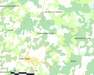
Saint-Amand-le-Petit
- commune in Haute-Vienne, France
- Country:
- Postal Code: 87120
- Coordinates: 45° 46' 29" N, 1° 45' 5" E
- GPS tracks (wikiloc): [Link]
- Area: 15.31 sq km
- Population: 99


Saint-Julien-le-Petit
- commune in Haute-Vienne, France
- Country:
- Postal Code: 87460
- Coordinates: 45° 49' 24" N, 1° 42' 21" E
- GPS tracks (wikiloc): [Link]
- Area: 29.13 sq km
- Population: 288


Peyrat-le-Château
- commune in Haute-Vienne, France
- Country:
- Postal Code: 87470
- Coordinates: 45° 48' 46" N, 1° 46' 22" E
- GPS tracks (wikiloc): [Link]
- Area: 52.96 sq km
- Population: 952