Auvers (Auvers)

- commune in Haute-Loire, France
- Country:

- Postal Code: 43300
- Coordinates: 44° 59' 46" N, 3° 24' 8" E


- GPS tracks (wikiloc): [Link]
- Area: 21.5 sq km
- Population: 61
- Wikipedia en: wiki(en)
- Wikipedia: wiki(fr)
- Wikidata storage: Wikidata: Q269845
- Wikipedia Commons Category: [Link]
- Freebase ID: [/m/03nthl9]
- GeoNames ID: Alt: [6449012]
- SIREN number: [214300154]
- BnF ID: [15259920h]
- INSEE municipality code: 43015
Shares border with regions:


La Besseyre-Saint-Mary
- commune in Haute-Loire, France
- Country:
- Postal Code: 43170
- Coordinates: 44° 58' 12" N, 3° 25' 3" E
- GPS tracks (wikiloc): [Link]
- Area: 21.57 sq km
- Population: 109
Pinols
- commune in Haute-Loire, France
- Country:
- Postal Code: 43300
- Coordinates: 45° 3' 6" N, 3° 24' 49" E
- GPS tracks (wikiloc): [Link]
- Area: 34.92 sq km
- Population: 200
Desges
- commune in Haute-Loire, France
- Country:
- Postal Code: 43300
- Coordinates: 45° 1' 2" N, 3° 27' 8" E
- GPS tracks (wikiloc): [Link]
- Area: 16.83 sq km
- Population: 60

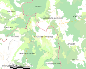
Paulhac-en-Margeride
- commune in Lozère, France
- Country:
- Postal Code: 48140
- Coordinates: 44° 56' 49" N, 3° 22' 50" E
- GPS tracks (wikiloc): [Link]
- Area: 15.79 sq km
- Population: 100


Clavières
- commune in Cantal, France
- Country:
- Postal Code: 15320
- Coordinates: 44° 59' 9" N, 3° 16' 36" E
- GPS tracks (wikiloc): [Link]
- Area: 44.66 sq km
- Population: 212