Barano d'Ischia (Barano d'Ischia)
.svg)
- Italian comune
 Hiking in Barano d'Ischia
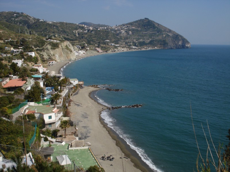
Barano d'Ischia, located on the island of Ischia in the Gulf of Naples, Italy, offers some delightful hiking opportunities amid its beautiful landscapes, stunning coastal views, and rich natural heritage. Here are a few key points to consider if you're planning a hiking experience there:
-
Scenic Trails: The island features a variety of hiking trails that range in difficulty and length. Many trails take you through lush vegetation, vineyards, and past charming villages. The paths often offer breathtaking views of the Mediterranean Sea and the surrounding islands.
-
Mount Epomeo: One of the island's main hiking attractions is Mount Epomeo, the highest peak in Ischia. The hike to the summit is challenging but rewarding, as it provides panoramic views of the island and the neighbors, including Capri and the mainland.
-
Natural Hot Springs: Ischia is known for its thermal springs, and some trails will lead you to these natural spas. After a long hike, relaxing in a thermal pool can be a perfect way to unwind.
-
Historic Sites: While hiking in Barano, you can also explore historic sites, including churches and ancient ruins, which add a cultural element to your outdoor adventures.
-
Weather Considerations: The best time for hiking in the region is during the spring and fall when the weather is mild. Summers can be hot, so it's essential to stay hydrated and protected from the sun.
-
Guided Tours: If you're unfamiliar with the area or prefer a structured approach, consider joining a guided hiking tour. Local guides can provide valuable insights into the island's flora, fauna, and history.
-
Preparation: Ensure you wear suitable hiking shoes, carry enough water, and pack some snacks. It's also a good idea to have a map or a GPS device, as cell service might be spotty in some areas.
Hiking in Barano d'Ischia can provide a unique blend of natural beauty, adventure, and relaxation, making it a perfect activity for outdoor enthusiasts visiting the island.
- Country:

- Postal Code: 80070
- Local Dialing Code: 081
- Licence Plate Code: NA
- Coordinates: 40° 43' 0" N, 13° 55' 0" E


- GPS tracks (wikiloc): [Link]
- AboveSeaLevel: 210 м m
- Area: 10.96 sq km
- Population: 10001
- Web site: http://www.comunebarano.it/
- Wikipedia en: wiki(en)
- Wikipedia: wiki(it)
- Wikidata storage: Wikidata: Q71838
- Wikipedia Commons Category: [Link]
- Freebase ID: [/m/0gn2vt]
- GeoNames ID: Alt: [6541679]
- OSM relation ID: [40705]
- TGN ID: [1043402]
- ISTAT ID: 063007
- Italian cadastre code: A617
Shares border with regions:


Casamicciola Terme
- Italian comune
Hiking in Casamicciola Terme
Casamicciola Terme, located on the island of Ischia in Italy, is known for its thermal spas and beautiful landscapes, making it a wonderful destination for hiking enthusiasts. The island itself is characterized by its volcanic terrain, lush greenery, and stunning coastal views....
- Country:
- Postal Code: 80074
- Local Dialing Code: 081
- Licence Plate Code: NA
- Coordinates: 40° 45' 0" N, 13° 55' 0" E
- GPS tracks (wikiloc): [Link]
- AboveSeaLevel: 22 м m
- Area: 5.85 sq km
- Population: 8205
- Web site: [Link]


Ischia
- Italian comune
Hiking in Ischia
Ischia, the largest island in the Bay of Naples, is a fantastic destination for hiking enthusiasts. Known for its volcanic landscape, lush greenery, and stunning coastal views, Ischia offers a variety of trails suitable for different skill levels....
- Country:
- Postal Code: 80077
- Local Dialing Code: 081
- Licence Plate Code: NA
- Coordinates: 40° 45' 0" N, 13° 57' 0" E
- GPS tracks (wikiloc): [Link]
- AboveSeaLevel: 2 м m
- Area: 8.14 sq km
- Population: 20118
- Web site: [Link]

Serrara Fontana
- Italian comune
Hiking in Serrara Fontana
Serrara Fontana is a charming village located on the island of Ischia in Italy, known for its stunning natural landscapes, thermal springs, and rich cultural history. Hiking around Serrara Fontana and the surrounding areas can be a fantastic experience, with varied trails that cater to different levels of hikers. Here are some highlights:...
- Country:
- Postal Code: 80070
- Local Dialing Code: 081
- Licence Plate Code: NA
- Coordinates: 40° 43' 0" N, 13° 54' 0" E
- GPS tracks (wikiloc): [Link]
- AboveSeaLevel: 800 м m
- Area: 6.44 sq km
- Population: 3139
- Web site: [Link]