Beaufou (Beaufou)

- commune in Vendée, France
- Country:

- Postal Code: 85170
- Coordinates: 46° 49' 25" N, 1° 31' 50" E


- GPS tracks (wikiloc): [Link]
- AboveSeaLevel: 60 м m
- Area: 29.06 sq km
- Population: 1465
- Web site: http://www.mairie-beaufou.fr/
- Wikipedia en: wiki(en)
- Wikipedia: wiki(fr)
- Wikidata storage: Wikidata: Q1066268
- Wikipedia Commons Category: [Link]
- Freebase ID: [/m/03qhk71]
- GeoNames ID: Alt: [6620195]
- SIREN number: [218500155]
- BnF ID: [15278145t]
- PACTOLS thesaurus ID: [pcrt2hlYSfP5mW]
- INSEE municipality code: 85015
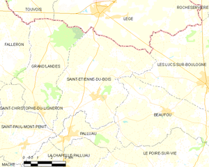
Shares border with regions:

Saint-Étienne-du-Bois
- commune in Vendée, France
- Country:
- Postal Code: 85670
- Coordinates: 46° 49' 52" N, 1° 35' 43" E
- GPS tracks (wikiloc): [Link]
- Area: 29.44 sq km
- Population: 2104
- Web site: [Link]


Palluau
- commune in Vendée, France
- Country:
- Postal Code: 85670
- Coordinates: 46° 48' 18" N, 1° 37' 11" E
- GPS tracks (wikiloc): [Link]
- Area: 7.43 sq km
- Population: 1085
- Web site: [Link]


Les Lucs-sur-Boulogne
- commune in Vendée, France
- Country:
- Postal Code: 85170
- Coordinates: 46° 50' 38" N, 1° 29' 37" E
- GPS tracks (wikiloc): [Link]
- Area: 53.15 sq km
- Population: 3392
- Web site: [Link]


Saligny, Vendée
- former commune in Vendée, France
- Country:
- Postal Code: 85170
- Coordinates: 46° 48' 28" N, 1° 25' 31" E
- GPS tracks (wikiloc): [Link]
- Area: 23.36 sq km
- Population: 2008


Le Poiré-sur-Vie
- commune in Vendée, France
- Country:
- Postal Code: 85170
- Coordinates: 46° 46' 7" N, 1° 30' 30" E
- GPS tracks (wikiloc): [Link]
- Area: 71.9 sq km
- Population: 8414
- Web site: [Link]