Beaumont-le-Roger (Beaumont-le-Roger)

- commune in Eure, France
- Country:

- Postal Code: 27170
- Coordinates: 49° 4' 48" N, 0° 46' 38" E


- GPS tracks (wikiloc): [Link]
- Area: 36.42 sq km
- Population: 3012
- Web site: http://www.beaumont-le-roger.fr
- Wikipedia en: wiki(en)
- Wikipedia: wiki(fr)
- Wikidata storage: Wikidata: Q326398
- Wikipedia Commons Category: [Link]
- Freebase ID: [/m/048mts]
- Freebase ID: [/m/048mts]
- GeoNames ID: Alt: [6447951]
- GeoNames ID: Alt: [6447951]
- SIREN number: [212700512]
- SIREN number: [212700512]
- BnF ID: [152532920]
- BnF ID: [152532920]
- VIAF ID: Alt: [247258725]
- VIAF ID: Alt: [247258725]
- PACTOLS thesaurus ID: [pcrtQE5ubyY9VK]
- PACTOLS thesaurus ID: [pcrtQE5ubyY9VK]
- MusicBrainz area ID: [d70c85b4-8635-4dd1-9a62-8652cef4b806]
- MusicBrainz area ID: [d70c85b4-8635-4dd1-9a62-8652cef4b806]
- INSEE municipality code: 27051
- INSEE municipality code: 27051
Shares border with regions:
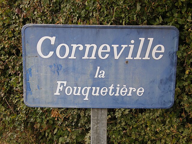
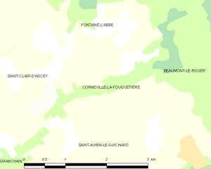
Corneville-la-Fouquetière
- commune in Eure, France
- Country:
- Postal Code: 27300
- Coordinates: 49° 3' 57" N, 0° 42' 19" E
- GPS tracks (wikiloc): [Link]
- Area: 3.99 sq km
- Population: 122


Le Noyer-en-Ouche
- commune in Eure, France
- Country:
- Postal Code: 27410
- Coordinates: 49° 0' 18" N, 0° 46' 21" E
- GPS tracks (wikiloc): [Link]
- Area: 10.9 sq km
- Population: 226


Saint-Aubin-le-Guichard
- former commune in Eure, France
- Country:
- Postal Code: 27410
- Coordinates: 49° 2' 22" N, 0° 42' 1" E
- GPS tracks (wikiloc): [Link]
- Area: 11.13 sq km
- Population: 311

Fontaine-l'Abbé
- commune in Eure, France
- Country:
- Postal Code: 27470
- Coordinates: 49° 5' 28" N, 0° 41' 35" E
- GPS tracks (wikiloc): [Link]
- Area: 13.23 sq km
- Population: 528
- Web site: [Link]


Grosley-sur-Risle
- commune in Eure, France
- Country:
- Postal Code: 27170
- Coordinates: 49° 3' 0" N, 0° 48' 46" E
- GPS tracks (wikiloc): [Link]
- Area: 13.18 sq km
- Population: 525

Gouttières
- former commune in Eure, France
- Country:
- Postal Code: 27410
- Coordinates: 49° 1' 26" N, 0° 44' 41" E
- GPS tracks (wikiloc): [Link]
- Area: 5.14 sq km
- Population: 200


Barc
- commune in Eure, France
- Country:
- Postal Code: 27170
- Coordinates: 49° 4' 12" N, 0° 49' 17" E
- GPS tracks (wikiloc): [Link]
- Area: 11.35 sq km
- Population: 1198
Launay
- commune in Eure, France
- Country:
- Postal Code: 27470
- Coordinates: 49° 6' 9" N, 0° 44' 32" E
- GPS tracks (wikiloc): [Link]
- Area: 2.26 sq km
- Population: 206

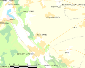
Beaumontel
- commune in Eure, France
- Country:
- Postal Code: 27170
- Coordinates: 49° 5' 19" N, 0° 45' 56" E
- GPS tracks (wikiloc): [Link]
- Area: 11.63 sq km
- Population: 676


Serquigny
- commune in Eure, France
- Country:
- Postal Code: 27470
- Coordinates: 49° 6' 35" N, 0° 42' 44" E
- GPS tracks (wikiloc): [Link]
- Area: 11.4 sq km
- Population: 2003
- Web site: [Link]