Berbiguières (Berbiguières)

- commune in Dordogne, France
- Country:

- Postal Code: 24220
- Coordinates: 44° 50' 5" N, 1° 2' 33" E


- GPS tracks (wikiloc): [Link]
- Area: 5.35 sq km
- Population: 176
- Wikipedia en: wiki(en)
- Wikipedia: wiki(fr)
- Wikidata storage: Wikidata: Q196565
- Wikipedia Commons Category: [Link]
- Freebase ID: [/m/02rdhgq]
- Freebase ID: [/m/02rdhgq]
- GeoNames ID: Alt: [3033430]
- GeoNames ID: Alt: [3033430]
- SIREN number: [212400360]
- SIREN number: [212400360]
- BnF ID: [152516871]
- BnF ID: [152516871]
- VIAF ID: Alt: [150417816]
- VIAF ID: Alt: [150417816]
- Library of Congress authority ID: Alt: [no98131445]
- Library of Congress authority ID: Alt: [no98131445]
- WOEID: [12638646]
- WOEID: [12638646]
- INSEE municipality code: 24036
- INSEE municipality code: 24036
Shares border with regions:

Castels
- former commune in Dordogne, France
- Country:
- Postal Code: 24220
- Coordinates: 44° 51' 58" N, 1° 3' 3" E
- GPS tracks (wikiloc): [Link]
- Area: 19.6 sq km
- Population: 645

Marnac
- commune in Dordogne, France
- Country:
- Postal Code: 24220
- Coordinates: 44° 50' 13" N, 1° 1' 33" E
- GPS tracks (wikiloc): [Link]
- Area: 7.92 sq km
- Population: 186


Allas-les-Mines
- commune in Dordogne, France
- Country:
- Postal Code: 24220
- Coordinates: 44° 50' 0" N, 1° 4' 20" E
- GPS tracks (wikiloc): [Link]
- Area: 7.04 sq km
- Population: 210

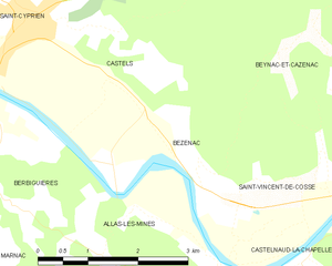
Bézenac
- former commune in Dordogne, France
- Country:
- Postal Code: 24220
- Coordinates: 44° 50' 37" N, 1° 5' 25" E
- GPS tracks (wikiloc): [Link]
- Area: 4.16 sq km
- Population: 154