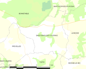
Bonnétable (Bonnétable)
- commune in Sarthe, France
- Country:

- Postal Code: 72110
- Coordinates: 48° 10' 43" N, 0° 25' 32" E


- GPS tracks (wikiloc): [Link]
- Area: 40.08 sq km
- Population: 3874
- Web site: http://www.ville-de-bonnetable.fr
- Wikipedia en: wiki(en)
- Wikipedia: wiki(fr)
- Wikidata storage: Wikidata: Q687154
- Wikipedia Commons Category: [Link]
- Freebase ID: [/m/03qj0cl]
- GeoNames ID: Alt: [3031723]
- SIREN number: [217200393]
- BnF ID: [15273597z]
- VIAF ID: Alt: [168807760]
- Library of Congress authority ID: Alt: [n91093738]
- MusicBrainz area ID: [193138a8-e5ae-4567-af1a-302efa291ee4]
- INSEE municipality code: 72039
Shares border with regions:


Torcé-en-Vallée
- commune in Sarthe, France
- Country:

- Postal Code: 72110
- Coordinates: 48° 8' 0" N, 0° 23' 46" E


- GPS tracks (wikiloc): [Link]
- Area: 16.86 sq km
- Population: 1375
- Web site: [Link]


Terrehault
- commune in Sarthe, France
- Country:

- Postal Code: 72110
- Coordinates: 48° 12' 18" N, 0° 24' 13" E


- GPS tracks (wikiloc): [Link]
- Area: 5.73 sq km
- Population: 133


Rouperroux-le-Coquet
- commune in Sarthe, France
- Country:

- Postal Code: 72110
- Coordinates: 48° 13' 37" N, 0° 25' 49" E


- GPS tracks (wikiloc): [Link]
- Area: 12.07 sq km
- Population: 302


Nogent-le-Bernard
- commune in Sarthe, France
- Country:

- Postal Code: 72110
- Coordinates: 48° 14' 10" N, 0° 29' 21" E


- GPS tracks (wikiloc): [Link]
- Area: 30.26 sq km
- Population: 946


Prévelles
- commune in Sarthe, France
- Country:

- Postal Code: 72110
- Coordinates: 48° 9' 10" N, 0° 29' 0" E


- GPS tracks (wikiloc): [Link]
- Area: 4.81 sq km
- Population: 218
- Web site: [Link]


Saint-Denis-des-Coudrais
- commune in Sarthe, France
- Country:

- Postal Code: 72110
- Coordinates: 48° 9' 1" N, 0° 30' 27" E


- GPS tracks (wikiloc): [Link]
- Area: 7 sq km
- Population: 122


Briosne-lès-Sables
- commune in Sarthe, France
- Country:

- Postal Code: 72110
- Coordinates: 48° 10' 27" N, 0° 23' 44" E


- GPS tracks (wikiloc): [Link]
- Area: 9.85 sq km
- Population: 570


Saint-Georges-du-Rosay
- commune in Sarthe, France
- Country:

- Postal Code: 72110
- Coordinates: 48° 12' 0" N, 0° 30' 7" E


- GPS tracks (wikiloc): [Link]
- Area: 17.31 sq km
- Population: 438
- Web site: [Link]


Saint-Célerin
- commune in Sarthe, France
- Country:

- Postal Code: 72110
- Coordinates: 48° 7' 24" N, 0° 25' 52" E


- GPS tracks (wikiloc): [Link]
- Area: 13.47 sq km
- Population: 873
