Borre (Borre)

- commune in Nord, France
- Country:

- Postal Code: 59190
- Coordinates: 50° 43' 53" N, 2° 35' 3" E


- GPS tracks (wikiloc): [Link]
- Area: 5.96 sq km
- Population: 614
- Wikipedia en: wiki(en)
- Wikipedia: wiki(fr)
- Wikidata storage: Wikidata: Q1135014
- Wikipedia Commons Category: [Link]
- Freebase ID: [/m/0263z5l]
- Freebase ID: [/m/0263z5l]
- GeoNames ID: Alt: [6450081]
- GeoNames ID: Alt: [6450081]
- SIREN number: [215900911]
- SIREN number: [215900911]
- BnF ID: [15266667t]
- BnF ID: [15266667t]
- VIAF ID: Alt: [243219402]
- VIAF ID: Alt: [243219402]
- INSEE municipality code: 59091
- INSEE municipality code: 59091
Shares border with regions:
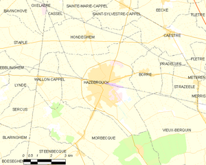
Hazebrouck
- commune in Nord, France
- Country:
- Postal Code: 59190
- Coordinates: 50° 43' 28" N, 2° 32' 18" E
- GPS tracks (wikiloc): [Link]
- AboveSeaLevel: 23 м m
- Area: 26.2 sq km
- Population: 21709
- Web site: [Link]


Pradelles
- commune in Nord, France
- Country:
- Postal Code: 59190
- Coordinates: 50° 43' 57" N, 2° 36' 16" E
- GPS tracks (wikiloc): [Link]
- Area: 3.27 sq km
- Population: 381


Vieux-Berquin
- commune in Nord, France
- Country:
- Postal Code: 59232
- Coordinates: 50° 41' 41" N, 2° 38' 40" E
- GPS tracks (wikiloc): [Link]
- Area: 25.96 sq km
- Population: 2516


Caëstre
- commune in Nord, France
- Country:
- Postal Code: 59190
- Coordinates: 50° 45' 30" N, 2° 36' 15" E
- GPS tracks (wikiloc): [Link]
- Area: 10.2 sq km
- Population: 1933
- Web site: [Link]