Bouchon (Bouchon)

- commune in Somme, France
- Country:

- Postal Code: 80830
- Coordinates: 50° 2' 6" N, 2° 1' 47" E


- GPS tracks (wikiloc): [Link]
- AboveSeaLevel: 23 м m
- Area: 4.6 sq km
- Population: 152
- Wikipedia en: wiki(en)
- Wikipedia: wiki(fr)
- Wikidata storage: Wikidata: Q979592
- Wikipedia Commons Category: [Link]
- Freebase ID: [/m/03mb4v4]
- GeoNames ID: Alt: [6617729]
- SIREN number: [218001113]
- BnF ID: [152766013]
- INSEE municipality code: 80117
Shares border with regions:


L'Étoile
- commune in Somme, France
- Country:
- Postal Code: 80830
- Coordinates: 50° 1' 14" N, 2° 2' 45" E
- GPS tracks (wikiloc): [Link]
- Area: 7.9 sq km
- Population: 1253

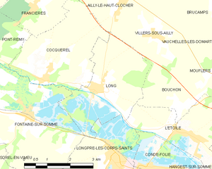
Long
- commune in Somme, France
- Country:
- Postal Code: 80510
- Coordinates: 50° 2' 22" N, 1° 58' 52" E
- GPS tracks (wikiloc): [Link]
- Area: 9.19 sq km
- Population: 627

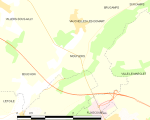
Mouflers
- commune in Somme, France
- Country:
- Postal Code: 80690
- Coordinates: 50° 2' 49" N, 2° 2' 56" E
- GPS tracks (wikiloc): [Link]
- Area: 3.53 sq km
- Population: 91


Villers-sous-Ailly
- commune in Somme, France
- Country:
- Postal Code: 80690
- Coordinates: 50° 3' 42" N, 2° 1' 0" E
- GPS tracks (wikiloc): [Link]
- Area: 6.26 sq km
- Population: 190