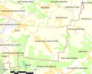
Bourg-Beaudouin (Bourg-Beaudouin)

- commune in Eure, France
- Country:

- Postal Code: 27380
- Coordinates: 49° 23' 11" N, 1° 18' 25" E


- GPS tracks (wikiloc): [Link]
- AboveSeaLevel: 135 м m
- Area: 5.33 sq km
- Population: 721
- Wikipedia en: wiki(en)
- Wikipedia: wiki(fr)
- Wikidata storage: Wikidata: Q1009078
- Wikipedia Commons Category: [Link]
- Freebase ID: [/m/03mhqrb]
- Freebase ID: [/m/03mhqrb]
- GeoNames ID: Alt: [6616277]
- GeoNames ID: Alt: [6616277]
- SIREN number: [212701049]
- SIREN number: [212701049]
- BnF ID: [152533432]
- BnF ID: [152533432]
- INSEE municipality code: 27104
- INSEE municipality code: 27104
Shares border with regions:


Renneville
- commune in Eure, France
- Country:
- Postal Code: 27910
- Coordinates: 49° 24' 9" N, 1° 19' 14" E
- GPS tracks (wikiloc): [Link]
- AboveSeaLevel: 143 м m
- Area: 6.3 sq km
- Population: 196


Mesnil-Raoul
- commune in Seine-Maritime, France
- Country:
- Postal Code: 76520
- Coordinates: 49° 23' 48" N, 1° 16' 28" E
- GPS tracks (wikiloc): [Link]
- Area: 6.76 sq km
- Population: 955
- Web site: [Link]


Fresne-le-Plan
- commune in Seine-Maritime, France
- Country:
- Postal Code: 76520
- Coordinates: 49° 24' 45" N, 1° 17' 42" E
- GPS tracks (wikiloc): [Link]
- Area: 6.88 sq km
- Population: 625

La Neuville-Chant-d'Oisel
- commune in Seine-Maritime, France
- Country:
- Postal Code: 76520
- Coordinates: 49° 22' 4" N, 1° 14' 35" E
- GPS tracks (wikiloc): [Link]
- AboveSeaLevel: 168 м m
- Area: 21.83 sq km
- Population: 2242
- Web site: [Link]

Radepont
- commune in Eure, France
- Country:
- Postal Code: 27380
- Coordinates: 49° 21' 4" N, 1° 19' 42" E
- GPS tracks (wikiloc): [Link]
- Area: 15.81 sq km
- Population: 663