Bursard (Bursard)

- commune in Orne, France
- Country:

- Postal Code: 61500
- Coordinates: 48° 32' 25" N, 0° 12' 40" E


- GPS tracks (wikiloc): [Link]
- Area: 10.55 sq km
- Population: 207
- Wikipedia en: wiki(en)
- Wikipedia: wiki(fr)
- Wikidata storage: Wikidata: Q368714
- Wikipedia Commons Category: [Link]
- Freebase ID: [/m/03qgqnq]
- Freebase ID: [/m/03qgqnq]
- GeoNames ID: Alt: [6450205]
- GeoNames ID: Alt: [6450205]
- SIREN number: [216100685]
- SIREN number: [216100685]
- BnF ID: [15268003d]
- BnF ID: [15268003d]
- INSEE municipality code: 61068
- INSEE municipality code: 61068
Shares border with regions:


Ménil-Erreux
- commune in Orne, France
- Country:
- Postal Code: 61250
- Coordinates: 48° 30' 26" N, 0° 11' 18" E
- GPS tracks (wikiloc): [Link]
- Area: 11.05 sq km
- Population: 224


Neauphe-sous-Essai
- commune in Orne, France
- Country:
- Postal Code: 61500
- Coordinates: 48° 33' 56" N, 0° 12' 38" E
- GPS tracks (wikiloc): [Link]
- Area: 11.43 sq km
- Population: 207

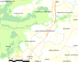
Saint-Gervais-du-Perron
- commune in Orne, France
- Country:
- Postal Code: 61500
- Coordinates: 48° 31' 58" N, 0° 9' 35" E
- GPS tracks (wikiloc): [Link]
- Area: 11.28 sq km
- Population: 386


Essay
- commune in Orne, France
- Country:
- Postal Code: 61500
- Coordinates: 48° 32' 28" N, 0° 14' 49" E
- GPS tracks (wikiloc): [Link]
- Area: 15.99 sq km
- Population: 520
- Web site: [Link]