canton of Estissac (canton d'Estissac)
- canton of France
- Country:

- Capital: Estissac
- Coordinates: 48° 16' 0" N, 3° 48' 0" E


- GPS tracks (wikiloc): [Link]
- Wikidata storage: Wikidata: Q1725246
- INSEE canton code: [1011]
Includes regions:


Chennegy
- commune in Aube, France
- Country:
- Postal Code: 10190
- Coordinates: 48° 13' 28" N, 3° 51' 13" E
- GPS tracks (wikiloc): [Link]
- Area: 23.19 sq km
- Population: 437

Estissac
- commune in Aube, France
- Country:
- Postal Code: 10190
- Coordinates: 48° 16' 9" N, 3° 48' 22" E
- GPS tracks (wikiloc): [Link]
- Area: 25.66 sq km
- Population: 1885


Fontvannes
- commune in Aube, France
- Country:
- Postal Code: 10190
- Coordinates: 48° 16' 44" N, 3° 52' 22" E
- GPS tracks (wikiloc): [Link]
- Area: 13.01 sq km
- Population: 716


Bercenay-en-Othe
- commune in Aube, France
- Country:
- Postal Code: 10190
- Coordinates: 48° 12' 32" N, 3° 53' 37" E
- GPS tracks (wikiloc): [Link]
- Area: 17.85 sq km
- Population: 469


Bucey-en-Othe
- commune in Aube, France
- Country:
- Postal Code: 10190
- Coordinates: 48° 15' 33" N, 3° 51' 51" E
- GPS tracks (wikiloc): [Link]
- Area: 13.03 sq km
- Population: 423


Prugny
- commune in Aube, France
- Country:
- Postal Code: 10190
- Coordinates: 48° 14' 46" N, 3° 56' 39" E
- GPS tracks (wikiloc): [Link]
- Area: 8.62 sq km
- Population: 382


Neuville-sur-Vanne
- commune in Aube, France
- Country:
- Postal Code: 10190
- Coordinates: 48° 15' 20" N, 3° 46' 50" E
- GPS tracks (wikiloc): [Link]
- AboveSeaLevel: 135 м m
- Area: 17.25 sq km
- Population: 420

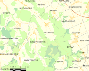
Vauchassis
- commune in Aube, France
- Country:
- Postal Code: 10190
- Coordinates: 48° 13' 23" N, 3° 55' 28" E
- GPS tracks (wikiloc): [Link]
- Area: 24.17 sq km
- Population: 503


Villemaur-sur-Vanne
- former commune in Aube, France
- Country:
- Postal Code: 10190
- Coordinates: 48° 15' 24" N, 3° 43' 41" E
- GPS tracks (wikiloc): [Link]
- Area: 19.65 sq km
- Population: 489


Messon
- commune in Aube, France
- Country:
- Postal Code: 10190
- Coordinates: 48° 15' 54" N, 3° 54' 24" E
- GPS tracks (wikiloc): [Link]
- Area: 11.49 sq km
- Population: 467