
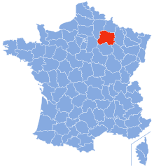
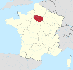
Grand Est (Grand Est)

- administrative region of France
 Hiking in Grand Est
Grand Est, a beautiful region in northeastern France, offers a diverse array of hiking opportunities. The region is characterized by a mix of picturesque landscapes, including rolling hills, vineyards, dense forests, and the stunning Vosges Mountains. Here are some key points about hiking in Grand Est:
1.
- Vosges Mountains: Known for their rugged beauty, the Vosges provide numerous trails that cater to all skill levels. The GR5 long-distance trail runs through this mountain range, offering breathtaking views and various landscapes.
- Champagne-Ardenne: This area is notable for its rolling vineyards and offers scenic trails that pass through charming wine villages, allowing hikers to enjoy both nature and local culture.
- Alsace Region: Hiking here provides an opportunity to explore a mix of charming villages, vineyards, and the picturesque Alsatian countryside, including the famous Alsace Wine Route.
2.
- The region is well-equipped with a network of marked hiking trails, including both short day hikes and long multi-day treks. The GR (Grande Randonnée) trails are particularly popular, such as GR5 and GR53, which traverse beautiful parts of the Vosges.
3.
- Many trails in Grand Est offer the chance to explore historical landmarks, castles, and remnants from various eras, including medieval times. The combination of nature and history makes hiking here a culturally enriching experience.
4.
- The region is home to diverse flora and fauna. As you hike through the forests and mountains, you may encounter unique wildlife and a variety of plant species, particularly in the Vosges where the landscape varies from deciduous to coniferous forests.
5.
- Many trailheads are easily accessible from major towns and cities in the region, making it convenient for both day hikes and longer excursions. Public transportation options exist in urban areas, adding to the accessibility.
6.
- Ballons des Vosges Nature Park: This area offers numerous hiking trails with varying difficulty levels and provides stunning vistas.
- Mont Sainte-Odile: A popular spot with panoramic views and a mix of hiking trails.
- Forêt de la Hutte: A forested area great for a leisurely hike, interspersed with natural beauty.
7.
- Depending on the specific trail and your preferences, late spring to early autumn (May to September) is typically the best time for hiking in Grand Est, as the weather is usually mild and the trails are well-maintained.
8.
- Always check the weather and trail conditions before heading out. It's also advisable to carry sufficient water, snacks, a map, and possibly a first-aid kit, especially when hiking in more remote areas.
Whether you're looking for a peaceful walk through vineyards, a challenging trek in the mountains, or an exploration of charming towns, hiking in Grand Est has something to offer for everyone.
- Country:

- Capital: Strasbourg
- Coordinates: 48° 35' 56" N, 7° 45' 36" E


- GPS tracks (wikiloc): [Link]
- Area: 57433 sq km
- Population: 5555186
- Web site: http://www.grandest.fr/
- Wikipedia en: wiki(en)
- Wikipedia: wiki(fr)
- Wikidata storage: Wikidata: Q18677983
- Wikipedia Commons Gallery: [Link]
- Wikipedia Commons Category: [Link]
- Wikipedia Commons Maps Category: [Link]
- Freebase ID: [/m/012ngsvz]
- GeoNames ID: Alt: [11071622]
- SIREN number: [200052264]
- BnF ID: [17023112j]
- VIAF ID: Alt: [315170666]
- OSM relation ID: [3792876]
- archINFORM location ID: [3274]
- MusicBrainz area ID: [7ced1904-076d-4627-b6cf-a4a48b361a7d]
- Encyclopædia Universalis ID: [alsace-champagne-ardenne-lorraine-region-administrative]
- Twitter username: Alt: [regiongrandest]
- INSEE region code: [44]
- AAT ID: [8711850]
- ISO 3166-2 code: FR-GES
Includes regions:

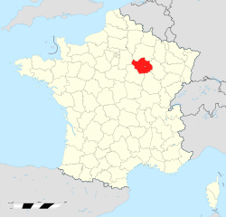
Marne
- French department
- Country:
- Capital: Châlons-en-Champagne
- Coordinates: 49° 0' 0" N, 4° 15' 0" E
- GPS tracks (wikiloc): [Link]
- Area: 8162 sq km
- Population: 572293
- Web site: [Link]


Haute-Marne
- French department
- Country:
- Capital: Chaumont
- Coordinates: 48° 5' 0" N, 5° 15' 0" E
- GPS tracks (wikiloc): [Link]
- Area: 6211 sq km
- Population: 179154
- Web site: [Link]


Meurthe-et-Moselle
- French department
- Country:
- Capital: Nancy
- Coordinates: 48° 40' 0" N, 6° 10' 0" E
- GPS tracks (wikiloc): [Link]
- Area: 5246 sq km
- Population: 734403
- Web site: [Link]


Meuse
- French department
- Country:
- Capital: Bar-le-Duc
- Coordinates: 48° 57' 56" N, 5° 22' 40" E
- GPS tracks (wikiloc): [Link]
- Area: 6211 sq km
- Population: 190626
- Web site: [Link]


Moselle
- French department
- Country:
- Capital: Metz
- Coordinates: 49° 2' 2" N, 6° 39' 43" E
- GPS tracks (wikiloc): [Link]
- Area: 6216 sq km
- Population: 1044486
- Web site: [Link]


Bas-Rhin
- French department
- Country:
- Capital: Strasbourg
- Coordinates: 48° 49' 0" N, 7° 47' 0" E
- GPS tracks (wikiloc): [Link]
- Area: 4755 sq km
- Population: 1121407
- Web site: [Link]

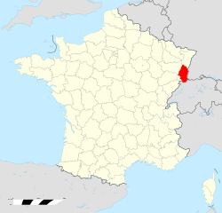
Haut-Rhin
- French department
Hiking in Haut-Rhin
Haut-Rhin, located in the Alsace region of France, offers some stunning hiking opportunities. The region is characterized by its picturesque landscapes, charming villages, and a rich cultural heritage, making it an excellent destination for hikers of all levels. Here are some highlights and tips for hiking in Haut-Rhin:...
- Country:
- Capital: Colmar
- Coordinates: 47° 57' 51" N, 7° 19' 11" E
- GPS tracks (wikiloc): [Link]
- Area: 3525 sq km
- Population: 762743
- Web site: [Link]


Vosges
- French department
- Country:
- Capital: Épinal
- Coordinates: 48° 10' 0" N, 6° 25' 0" E
- GPS tracks (wikiloc): [Link]
- Area: 5874 sq km
- Population: 372016
- Web site: [Link]


Ardennes
- department in France
- Country:
- Capital: Charleville-Mézières
- Coordinates: 49° 34' 43" N, 4° 35' 12" E
- GPS tracks (wikiloc): [Link]
- Area: 5229 sq km
- Population: 277752
- Web site: [Link]

Aube
- French department
- Country:
- Capital: Troyes
- Coordinates: 48° 20' 0" N, 4° 10' 0" E
- GPS tracks (wikiloc): [Link]
- Area: 6004 sq km
- Population: 309056
- Web site: [Link]
Shares border with regions:

Canton of Solothurn
- canton of Switzerland
Hiking in Canton of Solothurn
Hiking in the Canton of Solothurn offers a fantastic blend of natural beauty, historical sites, and picturesque villages. Located in Switzerland, Solothurn is known for its picturesque landscapes, ranging from rolling hills to stunning valleys and the scenic banks of the River Aare....
- Country:

- Capital: Solothurn
- Licence Plate Code: SO
- Coordinates: 47° 9' 0" N, 7° 38' 0" E
- GPS tracks (wikiloc): [Link]
- AboveSeaLevel: 432 м m
- Area: 790.45 sq km
- Web site: [Link]


Rhineland-Palatinate
- state of Germany
Hiking in Rhineland-Palatinate
Rhineland-Palatinate, located in western Germany, is a fantastic destination for hiking enthusiasts. This region is known for its diverse landscapes, ranging from the rolling vineyards of the Moselle Valley to the rugged terrain of the Eifel Mountains and the picturesque trails of the Rhine Gorge....
- Country:

- Capital: Mainz
- Coordinates: 49° 54' 47" N, 7° 26' 59" E
- GPS tracks (wikiloc): [Link]
- AboveSeaLevel: 0 м m
- Area: 19853.36 sq km
- Population: 4011582
- Web site: [Link]


Saarland
- state of Germany
Hiking in Saarland
Saarland, one of the smaller states in Germany, offers a range of beautiful hiking opportunities, combining lush landscapes, historical sites, and charming villages. Here's a brief overview of what to expect when hiking in Saarland:...
- Country:
- Capital: Saarbrücken
- Coordinates: 49° 22' 38" N, 6° 52' 42" E
- GPS tracks (wikiloc): [Link]
- Area: 2570.0 sq km
- Population: 995597
- Web site: [Link]


Basel-Landschaft
- canton of Switzerland
Hiking in Basel-Landschaft
Hiking in the Canton of Basel-Landschaft, located in Switzerland, offers an excellent opportunity to explore the region's beautiful landscapes, charming villages, and diverse ecosystems. Here are some key points to consider when planning your hike in this area:...
- Country:
- Capital: Liestal
- Licence Plate Code: BL
- Coordinates: 47° 27' 47" N, 7° 45' 21" E
- GPS tracks (wikiloc): [Link]
- AboveSeaLevel: 327 м m
- Area: 517.67 sq km
- Web site: [Link]

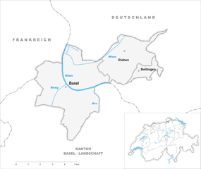
Basel-Stadt
- canton of Switzerland
Hiking in Basel-Stadt
Hiking in the Canton of Basel-Stadt offers a unique blend of urban landscapes and natural surroundings. Though Basel-Stadt is one of the smallest cantons in Switzerland and is largely urban, it provides access to beautiful parks, scenic riversides, and nearby regions that are perfect for hiking....
- Country:
- Capital: Basel
- Licence Plate Code: BS
- Coordinates: 47° 34' 0" N, 7° 36' 0" E
- GPS tracks (wikiloc): [Link]
- AboveSeaLevel: 260 м m
- Area: 36.95 sq km
- Population: 200256
- Web site: [Link]


Canton of Jura
- canton of Switzerland
Hiking in Canton of Jura
Hiking in the Canton of Jura, Switzerland, is a fantastic experience for outdoor enthusiasts. This region is known for its stunning landscapes, rolling hills, dense forests, and picturesque Jura mountains. Here are some key points to consider if you're planning to hike in the Canton of Jura:...
- Country:
- Capital: Delémont
- Licence Plate Code: JU
- Coordinates: 47° 22' 0" N, 7° 9' 0" E
- GPS tracks (wikiloc): [Link]
- AboveSeaLevel: 435 м m
- Area: 838.51 sq km
- Population: 69100
- Web site: [Link]

Île-de-France
- region in France where the French capital Paris is located
- Country:
- Capital: Paris
- Local Dialing Code: 01
- Coordinates: 48° 51' 8" N, 2° 19' 3" E
- GPS tracks (wikiloc): [Link]
- Area: 12012 sq km
- Population: 12082144
- Web site: [Link]
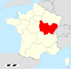
Bourgogne-Franche-Comté
- region of France
Hiking in Bourgogne-Franche-Comté
Bourgogne-Franche-Comté, located in east-central France, is a region rich in natural beauty, history, and diverse landscapes, making it an excellent destination for hiking enthusiasts. Here are some highlights to consider when planning your hiking adventures in the area:...
- Country:
- Capital: Dijon
- Coordinates: 47° 14' 4" N, 6° 1' 50" E
- GPS tracks (wikiloc): [Link]
- Area: 47784 sq km
- Population: 2820940
- Web site: [Link]


Hauts-de-France
- administrative region of France
- Country:
- Capital: Lille
- Coordinates: 49° 55' 14" N, 2° 42' 11" E
- GPS tracks (wikiloc): [Link]
- Area: 31813 sq km
- Population: 6009976
- Web site: [Link]


Baden-Württemberg
- federal state in the South-West of Germany
Hiking in Baden-Württemberg
Baden-Württemberg, located in southwestern Germany, is a fantastic region for hiking enthusiasts. With its diverse landscapes, from the Black Forest to the Swabian Jura and picturesque vineyards along the Rhine River, the area offers a variety of trails suitable for all skill levels. Here are some highlights:...
- Country:
- Capital: Stuttgart
- Coordinates: 48° 32' 16" N, 9° 2' 28" E
- GPS tracks (wikiloc): [Link]
- AboveSeaLevel: 327 м m
- Area: 35751.65 sq km
- Population: 10703000
- Web site: [Link]