canton of Cayres (canton de Cayres)
- canton of France (until March 2015)
- Country:

- Capital: Cayres
- Coordinates: 44° 55' 32" N, 3° 48' 27" E


- GPS tracks (wikiloc): [Link]
- Wikidata storage: Wikidata: Q276373
- INSEE canton code: [4306]
Includes regions:

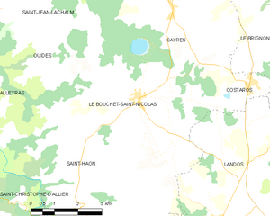
Le Bouchet-Saint-Nicolas
- commune in Haute-Loire, France
- Country:
- Postal Code: 43510
- Coordinates: 44° 53' 25" N, 3° 47' 21" E
- GPS tracks (wikiloc): [Link]
- Area: 19.31 sq km
- Population: 274

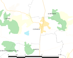
Costaros
- commune in Haute-Loire, France
- Country:
- Postal Code: 43490
- Coordinates: 44° 53' 42" N, 3° 51' 1" E
- GPS tracks (wikiloc): [Link]
- Area: 3.85 sq km
- Population: 572


Saint-Didier-d'Allier
- former commune in Haute-Loire, France
- Country:
- Postal Code: 43580
- Coordinates: 44° 59' 14" N, 3° 41' 36" E
- GPS tracks (wikiloc): [Link]
- Area: 7.71 sq km
- Population: 38


Cayres
- commune in Haute-Loire, France
- Country:
- Postal Code: 43510
- Coordinates: 44° 55' 32" N, 3° 48' 25" E
- GPS tracks (wikiloc): [Link]
- Area: 29.22 sq km
- Population: 728

Alleyras
- commune in Haute-Loire, France
- Country:
- Postal Code: 43580
- Coordinates: 44° 54' 23" N, 3° 40' 57" E
- GPS tracks (wikiloc): [Link]
- Area: 24.86 sq km
- Population: 161

Séneujols
- commune in Haute-Loire, France
- Country:
- Postal Code: 43510
- Coordinates: 44° 57' 36" N, 3° 46' 55" E
- GPS tracks (wikiloc): [Link]
- Area: 12.24 sq km
- Population: 315


Saint-Jean-Lachalm
- commune in Haute-Loire, France
- Country:
- Postal Code: 43510
- Coordinates: 44° 57' 25" N, 3° 43' 7" E
- GPS tracks (wikiloc): [Link]
- Area: 34.64 sq km
- Population: 282
Ouides
- commune in Haute-Loire, France
- Country:
- Postal Code: 43510
- Coordinates: 44° 54' 13" N, 3° 44' 16" E
- GPS tracks (wikiloc): [Link]
- Area: 10.69 sq km
- Population: 57