canton of La Fresnaye-sur-Chédouet (canton de La Fresnaye-sur-Chédouet)
- canton of France (until March 2015)
- Country:

- Capital: La Fresnaye-sur-Chédouet
- Coordinates: 48° 25' 58" N, 0° 15' 3" E


- GPS tracks (wikiloc): [Link]
- Wikidata storage: Wikidata: Q1348815
- INSEE canton code: [7211]
Includes regions:

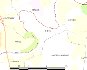
Chenay
- commune in Sarthe, France
- Country:
- Postal Code: 72610
- Coordinates: 48° 26' 58" N, 0° 9' 45" E
- GPS tracks (wikiloc): [Link]
- Area: 2.16 sq km
- Population: 224

Chassé
- former commune in Sarthe, France
- Country:
- Postal Code: 72670
- Coordinates: 48° 27' 0" N, 0° 12' 0" E
- GPS tracks (wikiloc): [Link]
- Population: 181

Roullée
- former commune in Sarthe, France
- Country:
- Postal Code: 72670
- Coordinates: 48° 27' 36" N, 0° 18' 0" E
- GPS tracks (wikiloc): [Link]
- Population: 243

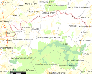
La Fresnaye-sur-Chédouet
- former commune in Sarthe, France
- Country:
- Postal Code: 72670
- Coordinates: 48° 26' 55" N, 0° 15' 15" E
- GPS tracks (wikiloc): [Link]
- Population: 945

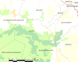
Louzes
- commune in Sarthe, France
- Country:
- Postal Code: 72600
- Coordinates: 48° 25' 39" N, 0° 18' 5" E
- GPS tracks (wikiloc): [Link]
- Area: 8.24 sq km
- Population: 100


Aillières-Beauvoir
- commune in Sarthe, France
- Country:
- Postal Code: 72600
- Coordinates: 48° 24' 18" N, 0° 19' 31" E
- GPS tracks (wikiloc): [Link]
- AboveSeaLevel: 278 м m
- Area: 15.07 sq km
- Population: 220


Neufchâtel-en-Saosnois
- commune in Sarthe, France
- Country:
- Postal Code: 72600
- Coordinates: 48° 22' 37" N, 0° 14' 43" E
- GPS tracks (wikiloc): [Link]
- Area: 23.41 sq km
- Population: 1032

Lignières-la-Carelle
- former commune in Sarthe, France
- Country:
- Postal Code: 72610
- Coordinates: 48° 26' 6" N, 0° 10' 31" E
- GPS tracks (wikiloc): [Link]
- Population: 384


Les Aulneaux
- commune in Sarthe, France
- Country:
- Postal Code: 72600
- Coordinates: 48° 26' 12" N, 0° 19' 57" E
- GPS tracks (wikiloc): [Link]
- Area: 8.17 sq km
- Population: 118


Blèves
- commune in Sarthe, France
- Country:
- Postal Code: 72600
- Coordinates: 48° 27' 27" N, 0° 20' 50" E
- GPS tracks (wikiloc): [Link]
- Area: 2.04 sq km
- Population: 97

Saint-Rigomer-des-Bois
- former commune in Sarthe, France
- Country:
- Postal Code: 72610
- Coordinates: 48° 23' 20" N, 0° 10' 18" E
- GPS tracks (wikiloc): [Link]
- Population: 464

Montigny
- former commune in Sarthe, France
- Country:
- Postal Code: 72670
- Coordinates: 48° 27' 25" N, 0° 11' 1" E
- GPS tracks (wikiloc): [Link]
- Population: 28