canton of Saint-Hilaire-de-Villefranche (canton de Saint-Hilaire-de-Villefranche)
- canton of France
- Country:

- Capital: Saint-Hilaire-de-Villefranche
- Coordinates: 45° 51' 6" N, 0° 28' 45" E


- GPS tracks (wikiloc): [Link]
- Wikidata storage: Wikidata: Q1727197
- INSEE canton code: [1728]
Includes regions:

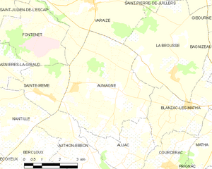
Aumagne
- commune in Charente-Maritime, France
- Country:
- Postal Code: 17770
- Coordinates: 45° 52' 30" N, 0° 24' 13" E
- GPS tracks (wikiloc): [Link]
- Area: 20.5 sq km
- Population: 708
- Web site: [Link]


Brizambourg
- commune in Charente-Maritime, France
- Country:
- Postal Code: 17770
- Coordinates: 45° 49' 20" N, 0° 28' 50" E
- GPS tracks (wikiloc): [Link]
- Area: 21.26 sq km
- Population: 872


Juicq
- commune in Charente-Maritime, France
- Country:
- Postal Code: 17770
- Coordinates: 45° 50' 37" N, 0° 33' 39" E
- GPS tracks (wikiloc): [Link]
- Area: 9.25 sq km
- Population: 283


Nantillé
- commune in Charente-Maritime, France
- Country:
- Postal Code: 17770
- Coordinates: 45° 51' 14" N, 0° 28' 3" E
- GPS tracks (wikiloc): [Link]
- Area: 10.78 sq km
- Population: 326


Aujac
- commune in Charente-Maritime, France
- Country:
- Postal Code: 17770
- Coordinates: 45° 50' 39" N, 0° 23' 44" E
- GPS tracks (wikiloc): [Link]
- Area: 8.73 sq km
- Population: 349

Saint-Hilaire-de-Villefranche
- commune in Charente-Maritime, France
- Country:
- Postal Code: 17770
- Coordinates: 45° 51' 3" N, 0° 31' 47" E
- GPS tracks (wikiloc): [Link]
- Area: 22.19 sq km
- Population: 1226


Authon-Ébéon
- commune in Charente-Maritime, France
- Country:
- Postal Code: 17770
- Coordinates: 45° 50' 10" N, 0° 24' 30" E
- GPS tracks (wikiloc): [Link]
- AboveSeaLevel: 30 м m
- Area: 11.65 sq km
- Population: 402


Sainte-Même
- commune in Charente-Maritime, France
- Country:
- Postal Code: 17770
- Coordinates: 45° 52' 36" N, 0° 27' 35" E
- GPS tracks (wikiloc): [Link]
- Area: 6.15 sq km
- Population: 249


La Frédière
- commune in Charente-Maritime, France
- Country:
- Postal Code: 17770
- Coordinates: 45° 51' 39" N, 0° 34' 12" E
- GPS tracks (wikiloc): [Link]
- Area: 2.89 sq km
- Population: 73


Bercloux
- commune in Charente-Maritime, France
- Country:
- Postal Code: 17770
- Coordinates: 45° 50' 7" N, 0° 28' 17" E
- GPS tracks (wikiloc): [Link]
- Area: 9.35 sq km
- Population: 442