canton of Saint-Julien-Chapteuil (canton de Saint-Julien-Chapteuil)
- canton of France (until March 2015)
- Country:

- Capital: Saint-Julien-Chapteuil
- Coordinates: 45° 2' 13" N, 4° 3' 47" E


- GPS tracks (wikiloc): [Link]
- Wikidata storage: Wikidata: Q276491
- INSEE canton code: [4323]
Includes regions:


Saint-Julien-Chapteuil
- commune in Haute-Loire, France
- Country:
- Postal Code: 43260
- Coordinates: 45° 2' 5" N, 4° 3' 40" E
- GPS tracks (wikiloc): [Link]
- Area: 28.26 sq km
- Population: 1880


Saint-Étienne-Lardeyrol
- commune in Haute-Loire, France
- Country:
- Postal Code: 43260
- Coordinates: 45° 4' 17" N, 4° 0' 4" E
- GPS tracks (wikiloc): [Link]
- Area: 11.8 sq km
- Population: 758


Montusclat
- commune in Haute-Loire, France
- Country:
- Postal Code: 43260
- Coordinates: 45° 0' 48" N, 4° 7' 28" E
- GPS tracks (wikiloc): [Link]
- Area: 10.47 sq km
- Population: 143
Queyrières
- commune in Haute-Loire, France
- Country:
- Postal Code: 43260
- Coordinates: 45° 4' 20" N, 4° 5' 53" E
- GPS tracks (wikiloc): [Link]
- Area: 13.95 sq km
- Population: 307

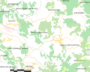
Saint-Pierre-Eynac
- commune in Haute-Loire, France
- Country:
- Postal Code: 43260
- Coordinates: 45° 2' 48" N, 4° 2' 2" E
- GPS tracks (wikiloc): [Link]
- Area: 23.99 sq km
- Population: 1103
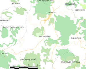
Saint-Hostien
- commune in Haute-Loire, France
- Country:
- Postal Code: 43260
- Coordinates: 45° 4' 20" N, 4° 2' 52" E
- GPS tracks (wikiloc): [Link]
- Area: 13.49 sq km
- Population: 742
- Web site: [Link]


Le Pertuis
- commune in Haute-Loire, France
- Country:
- Postal Code: 43200
- Coordinates: 45° 5' 47" N, 4° 3' 32" E
- GPS tracks (wikiloc): [Link]
- Area: 11.89 sq km
- Population: 440
Lantriac
- commune in Haute-Loire, France
- Country:
- Postal Code: 43260
- Coordinates: 45° 0' 3" N, 4° 0' 15" E
- GPS tracks (wikiloc): [Link]
- Area: 22.83 sq km
- Population: 1935