canton of Saint-Loup-Lamairé (canton de Saint-Loup-Lamairé)
- canton of France
- Country:

- Capital: Saint-Loup-Lamairé
- Coordinates: 46° 47' 0" N, 0° 9' 57" E


- GPS tracks (wikiloc): [Link]
- Wikidata storage: Wikidata: Q1727239
- INSEE canton code: [7924]
Includes regions:

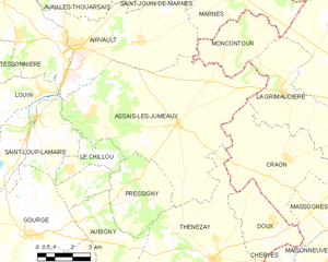
Assais-les-Jumeaux
- commune in Deux-Sèvres, France
- Country:
- Postal Code: 79600
- Coordinates: 46° 47' 18" N, 0° 3' 33" E
- GPS tracks (wikiloc): [Link]
- AboveSeaLevel: 110 м m
- Area: 52.26 sq km
- Population: 788
Le Chillou
- commune in Deux-Sèvres, France
- Country:
- Postal Code: 79600
- Coordinates: 46° 45' 50" N, 0° 8' 19" E
- GPS tracks (wikiloc): [Link]
- Area: 5.12 sq km
- Population: 173


Gourgé
- commune in Deux-Sèvres, France
- Country:
- Postal Code: 79200
- Coordinates: 46° 43' 42" N, 0° 9' 57" E
- GPS tracks (wikiloc): [Link]
- Area: 50.43 sq km
- Population: 960
- Web site: [Link]
Tessonnière
- commune in Deux-Sèvres, France
- Country:
- Postal Code: 79600
- Coordinates: 46° 48' 46" N, 0° 11' 28" E
- GPS tracks (wikiloc): [Link]
- Area: 14.6 sq km
- Population: 312


Maisontiers
- commune in Deux-Sèvres, France
- Country:
- Postal Code: 79600
- Coordinates: 46° 46' 37" N, 0° 14' 57" E
- GPS tracks (wikiloc): [Link]
- Area: 18.29 sq km
- Population: 161


Louin
- commune in Deux-Sèvres, France
- Country:
- Postal Code: 79600
- Coordinates: 46° 48' 8" N, 0° 9' 39" E
- GPS tracks (wikiloc): [Link]
- Area: 20.56 sq km
- Population: 690


Saint-Loup-Lamairé
- commune in Deux-Sèvres, France
- Country:
- Postal Code: 79600
- Coordinates: 46° 47' 18" N, 0° 9' 55" E
- GPS tracks (wikiloc): [Link]
- AboveSeaLevel: 130 м m
- Area: 21.8 sq km
- Population: 970