canton of Acheux-en-Amiénois (canton d'Acheux-en-Amiénois)

- canton of France
- Country:

- Capital: Acheux-en-Amiénois
- Coordinates: 50° 4' 27" N, 2° 32' 1" E


- GPS tracks (wikiloc): [Link]
- Wikipedia en: wiki(en)
- Wikipedia: wiki(fr)
- Wikidata storage: Wikidata: Q1724022
- Freebase ID: [/m/03y6hp5]
- INSEE canton code: [8003]
Includes regions:


Bertrancourt
- commune in Somme, France
- Country:
- Postal Code: 80560
- Coordinates: 50° 5' 38" N, 2° 33' 21" E
- GPS tracks (wikiloc): [Link]
- Area: 6.09 sq km
- Population: 227


Harponville
- commune in Somme, France
- Country:
- Postal Code: 80560
- Coordinates: 50° 2' 7" N, 2° 30' 8" E
- GPS tracks (wikiloc): [Link]
- Area: 2.75 sq km
- Population: 192


Bus-lès-Artois
- commune in Somme, France
- Country:
- Postal Code: 80560
- Coordinates: 50° 6' 12" N, 2° 32' 29" E
- GPS tracks (wikiloc): [Link]
- AboveSeaLevel: 140 м m
- Area: 6.74 sq km
- Population: 136

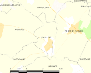
Léalvillers
- commune in Somme, France
- Country:
- Postal Code: 80560
- Coordinates: 50° 3' 51" N, 2° 30' 37" E
- GPS tracks (wikiloc): [Link]
- Area: 2.23 sq km
- Population: 168


Hédauville
- commune in Somme, France
- Country:
- Postal Code: 80560
- Coordinates: 50° 2' 44" N, 2° 34' 4" E
- GPS tracks (wikiloc): [Link]
- Area: 4.04 sq km
- Population: 122


Saint-Léger-lès-Authie
- commune in Somme, France
- Country:
- Postal Code: 80560
- Coordinates: 50° 7' 34" N, 2° 30' 44" E
- GPS tracks (wikiloc): [Link]
- Area: 4.29 sq km
- Population: 93


Forceville
- commune in Somme, France
- Country:
- Postal Code: 80560
- Coordinates: 50° 3' 42" N, 2° 33' 24" E
- GPS tracks (wikiloc): [Link]
- Area: 7.57 sq km
- Population: 175
- Web site: [Link]
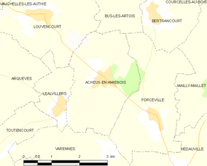
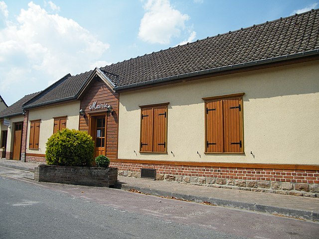
Acheux-en-Amiénois
- commune in Somme, France
- Country:
- Postal Code: 80560
- Coordinates: 50° 4' 25" N, 2° 31' 58" E
- GPS tracks (wikiloc): [Link]
- Area: 7.07 sq km
- Population: 618
- Web site: [Link]


Arquèves
- commune in Somme, France
- Country:
- Postal Code: 80560
- Coordinates: 50° 4' 18" N, 2° 28' 7" E
- GPS tracks (wikiloc): [Link]
- Area: 7.64 sq km
- Population: 162
- Web site: [Link]


Mailly-Maillet
- commune in Somme, France
- Country:
- Postal Code: 80560
- Coordinates: 50° 4' 47" N, 2° 36' 13" E
- GPS tracks (wikiloc): [Link]
- Area: 11.14 sq km
- Population: 613


Louvencourt
- commune in Somme, France
- Country:
- Postal Code: 80560
- Coordinates: 50° 5' 38" N, 2° 29' 57" E
- GPS tracks (wikiloc): [Link]
- Area: 7.74 sq km
- Population: 274


Marieux
- commune in Somme, France
- Country:
- Postal Code: 80560
- Coordinates: 50° 6' 21" N, 2° 26' 35" E
- GPS tracks (wikiloc): [Link]
- Area: 4.07 sq km
- Population: 114

Authie
- commune in Somme, France
- Country:
- Postal Code: 80560
- Coordinates: 50° 7' 11" N, 2° 29' 19" E
- GPS tracks (wikiloc): [Link]
- Area: 9.93 sq km
- Population: 298
- Web site: [Link]


Bayencourt
- commune in Somme, France
- Country:
- Postal Code: 80560
- Coordinates: 50° 7' 55" N, 2° 34' 25" E
- GPS tracks (wikiloc): [Link]
- Area: 1.84 sq km
- Population: 80


Coigneux
- commune in Somme, France
- Country:
- Postal Code: 80560
- Coordinates: 50° 7' 47" N, 2° 33' 6" E
- GPS tracks (wikiloc): [Link]
- Area: 2.88 sq km
- Population: 49


Colincamps
- commune in Somme, France
- Country:
- Postal Code: 80560
- Coordinates: 50° 6' 2" N, 2° 36' 1" E
- GPS tracks (wikiloc): [Link]
- Area: 4.38 sq km
- Population: 87

Senlis-le-Sec
- commune in Somme, France
- Country:
- Postal Code: 80300
- Coordinates: 50° 1' 31" N, 2° 34' 42" E
- GPS tracks (wikiloc): [Link]
- Area: 8.28 sq km
- Population: 295


Courcelles-au-Bois
- commune in Somme, France
- Country:
- Postal Code: 80560
- Coordinates: 50° 6' 15" N, 2° 35' 2" E
- GPS tracks (wikiloc): [Link]
- Area: 2.02 sq km
- Population: 83


Raincheval
- commune in Somme, France
- Country:
- Postal Code: 80600
- Coordinates: 50° 4' 24" N, 2° 26' 18" E
- GPS tracks (wikiloc): [Link]
- Area: 6.8 sq km
- Population: 285


Puchevillers
- commune in Somme, France
- Country:
- Postal Code: 80560
- Coordinates: 50° 3' 18" N, 2° 24' 37" E
- GPS tracks (wikiloc): [Link]
- Area: 14.24 sq km
- Population: 547
- Web site: [Link]
Hérissart
- commune in Somme, France
- Country:
- Postal Code: 80260
- Coordinates: 50° 1' 38" N, 2° 24' 59" E
- GPS tracks (wikiloc): [Link]
- Area: 7.39 sq km
- Population: 609


Thièvres
- commune in Somme, France
- Country:
- Postal Code: 62760
- Coordinates: 50° 7' 41" N, 2° 27' 20" E
- GPS tracks (wikiloc): [Link]
- Area: 3.67 sq km
- Population: 62

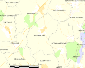
Englebelmer
- commune in Somme, France
- Country:
- Postal Code: 80300
- Coordinates: 50° 3' 38" N, 2° 36' 32" E
- GPS tracks (wikiloc): [Link]
- Area: 9.41 sq km
- Population: 304


Vauchelles-lès-Authie
- commune in Somme, France
- Country:
- Postal Code: 80560
- Coordinates: 50° 5' 52" N, 2° 28' 29" E
- GPS tracks (wikiloc): [Link]
- AboveSeaLevel: 100 м m
- Area: 4.7 sq km
- Population: 155


Varennes
- commune in Somme, France
- Country:
- Postal Code: 80560
- Coordinates: 50° 2' 59" N, 2° 32' 3" E
- GPS tracks (wikiloc): [Link]
- Area: 7.24 sq km
- Population: 217


Toutencourt
- commune in Somme, France
- Country:
- Postal Code: 80560
- Coordinates: 50° 2' 8" N, 2° 27' 40" E
- GPS tracks (wikiloc): [Link]
- Area: 14.37 sq km
- Population: 477