canton of Aigueperse (canton d'Aigueperse)

- canton of France
- Country:

- Capital: Aigueperse
- Coordinates: 46° 0' 57" N, 3° 12' 2" E


- GPS tracks (wikiloc): [Link]
- Population: 21618
- Wikipedia en: wiki(en)
- Wikipedia: wiki(fr)
- Wikidata storage: Wikidata: Q276363
- INSEE canton code: [6301]
Includes regions:


Artonne
- commune in Puy-de-Dôme, France
- Country:
- Postal Code: 63460
- Coordinates: 46° 0' 12" N, 3° 8' 38" E
- GPS tracks (wikiloc): [Link]
- Area: 17.48 sq km
- Population: 882


Effiat
- commune in Puy-de-Dôme, France
- Country:
- Postal Code: 63260
- Coordinates: 46° 2' 24" N, 3° 15' 20" E
- GPS tracks (wikiloc): [Link]
- Area: 19.96 sq km
- Population: 1107

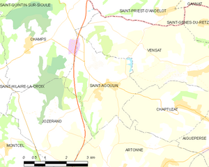
Saint-Agoulin
- commune in Puy-de-Dôme, France
- Country:
- Postal Code: 63260
- Coordinates: 46° 2' 27" N, 3° 8' 9" E
- GPS tracks (wikiloc): [Link]
- Area: 9.34 sq km
- Population: 333


Aigueperse
- commune in Puy-de-Dôme, France
- Country:
- Postal Code: 63260
- Coordinates: 46° 1' 21" N, 3° 12' 8" E
- GPS tracks (wikiloc): [Link]
- Area: 10.5 sq km
- Population: 2709
- Web site: [Link]


Chaptuzat
- commune in Puy-de-Dôme, France
- Country:
- Postal Code: 63260
- Coordinates: 46° 1' 55" N, 3° 10' 41" E
- GPS tracks (wikiloc): [Link]
- Area: 8.24 sq km
- Population: 494


Sardon
- commune in Puy-de-Dôme, France
- Country:
- Postal Code: 63260
- Coordinates: 45° 57' 46" N, 3° 13' 16" E
- GPS tracks (wikiloc): [Link]
- Area: 8.41 sq km
- Population: 311

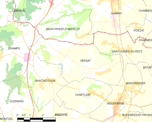
Vensat
- commune in Puy-de-Dôme, France
- Country:
- Postal Code: 63260
- Coordinates: 46° 2' 43" N, 3° 11' 7" E
- GPS tracks (wikiloc): [Link]
- Area: 16.11 sq km
- Population: 495
- Web site: [Link]
Aubiat
- commune in Puy-de-Dôme, France
- Country:
- Postal Code: 63260
- Coordinates: 45° 58' 40" N, 3° 10' 3" E
- GPS tracks (wikiloc): [Link]
- Area: 14.79 sq km
- Population: 900
- Web site: [Link]

Saint-Genès-du-Retz
- commune in Puy-de-Dôme, France
- Country:
- Postal Code: 63260
- Coordinates: 46° 3' 41" N, 3° 12' 52" E
- GPS tracks (wikiloc): [Link]
- Area: 8.24 sq km
- Population: 496


Bussières-et-Pruns
- commune in Puy-de-Dôme, France
- Country:
- Postal Code: 63260
- Coordinates: 46° 0' 23" N, 3° 13' 55" E
- GPS tracks (wikiloc): [Link]
- Area: 11.63 sq km
- Population: 436


Thuret
- commune in Puy-de-Dôme, France
- Country:
- Postal Code: 63260
- Coordinates: 45° 58' 8" N, 3° 15' 32" E
- GPS tracks (wikiloc): [Link]
- Area: 16.66 sq km
- Population: 914
- Web site: [Link]


Montpensier
- commune in Puy-de-Dôme, France
- Country:
- Postal Code: 63260
- Coordinates: 46° 2' 8" N, 3° 13' 11" E
- GPS tracks (wikiloc): [Link]
- Area: 7.24 sq km
- Population: 444