canton of Bourgtheroulde-Infreville (canton de Bourgtheroulde-Infreville)

- canton of France
- Country:

- Capital: Bourgtheroulde-Infreville
- Coordinates: 49° 17' 37" N, 0° 49' 25" E


- GPS tracks (wikiloc): [Link]
- Population: 27517
- Wikipedia en: wiki(en)
- Wikipedia: wiki(fr)
- Wikidata storage: Wikidata: Q1724579
- Wikipedia Commons Category: [Link]
- INSEE canton code: [2705]
Includes regions:


Voiscreville
- commune in Eure, France
- Country:
- Postal Code: 27520
- Coordinates: 49° 16' 51" N, 0° 46' 13" E
- GPS tracks (wikiloc): [Link]
- Area: 1.69 sq km
- Population: 127

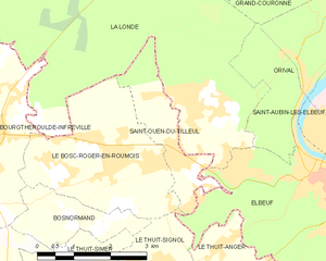
Saint-Ouen-du-Tilleul
- commune in Eure, France
- Country:
- Postal Code: 27670
- Coordinates: 49° 17' 38" N, 0° 56' 52" E
- GPS tracks (wikiloc): [Link]
- Area: 3.99 sq km
- Population: 1605


Thuit-Hébert
- former commune in Eure, France
- Country:
- Postal Code: 27520
- Coordinates: 49° 19' 18" N, 0° 50' 4" E
- GPS tracks (wikiloc): [Link]
- Area: 3.68 sq km
- Population: 313

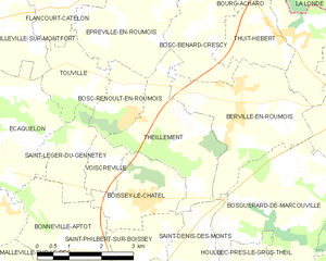
Theillement
- former commune in Eure, France
- Country:
- Postal Code: 27520
- Coordinates: 49° 17' 17" N, 0° 47' 58" E
- GPS tracks (wikiloc): [Link]
- Area: 7.14 sq km
- Population: 415


Saint-Denis-des-Monts
- commune in Eure, France
- Country:
- Postal Code: 27520
- Coordinates: 49° 15' 50" N, 0° 48' 22" E
- GPS tracks (wikiloc): [Link]
- Area: 3.88 sq km
- Population: 211
Saint-Philbert-sur-Boissey
- commune in Eure, France
- Country:
- Postal Code: 27520
- Coordinates: 49° 15' 17" N, 0° 47' 3" E
- GPS tracks (wikiloc): [Link]
- AboveSeaLevel: 145 м m
- Area: 3.03 sq km
- Population: 173

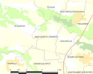
Saint-Léger-du-Gennetey
- commune in Eure, France
- Country:
- Postal Code: 27520
- Coordinates: 49° 17' 5" N, 0° 44' 55" E
- GPS tracks (wikiloc): [Link]
- Area: 3.27 sq km
- Population: 187