canton of Hesdin (canton de Hesdin)
- canton of France
- Country:

- Capital: Hesdin
- Coordinates: 50° 21' 27" N, 2° 0' 9" E


- GPS tracks (wikiloc): [Link]
- Wikipedia en: wiki(en)
- Wikipedia: wiki(fr)
- Wikidata storage: Wikidata: Q1725497
- Freebase ID: [/m/046qy5]
- INSEE canton code: [6226]
Includes regions:


Regnauville
- commune in Pas-de-Calais, France
- Country:

- Postal Code: 62140
- Coordinates: 50° 18' 50" N, 2° 0' 41" E


- GPS tracks (wikiloc): [Link]
- Area: 4.17 sq km
- Population: 213


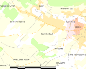
Marconnelle
- commune in Pas-de-Calais, France
- Country:

- Postal Code: 62140
- Coordinates: 50° 22' 26" N, 2° 0' 58" E


- GPS tracks (wikiloc): [Link]
- Area: 5.55 sq km
- Population: 1152


Labroye
- commune in Pas-de-Calais, France
- Country:

- Postal Code: 62140
- Coordinates: 50° 16' 42" N, 1° 59' 22" E


- GPS tracks (wikiloc): [Link]
- Area: 8.15 sq km
- Population: 167

Huby-Saint-Leu
- commune in Pas-de-Calais, France
- Country:

- Postal Code: 62140
- Coordinates: 50° 22' 56" N, 2° 2' 14" E


- GPS tracks (wikiloc): [Link]
- Area: 12.44 sq km
- Population: 902


La Loge
- commune in Pas-de-Calais, France
- Country:

- Postal Code: 62140
- Coordinates: 50° 24' 26" N, 2° 2' 0" E


- GPS tracks (wikiloc): [Link]
- Area: 0.68 sq km
- Population: 187


Hesdin
- commune in Pas-de-Calais, France
- Country:

- Postal Code: 62140
- Coordinates: 50° 22' 27" N, 2° 2' 12" E


- GPS tracks (wikiloc): [Link]
- Area: 0.93 sq km
- Population: 2213
- Web site: [Link]


Aubin-Saint-Vaast
- commune in Pas-de-Calais, France
- Country:

- Postal Code: 62140
- Coordinates: 50° 23' 44" N, 1° 58' 25" E


- GPS tracks (wikiloc): [Link]
- Area: 6.7 sq km
- Population: 770
- Web site: [Link]


Marconne
- commune in Pas-de-Calais, France
- Country:

- Postal Code: 62140
- Coordinates: 50° 22' 19" N, 2° 3' 4" E


- GPS tracks (wikiloc): [Link]
- Area: 4.18 sq km
- Population: 1122


Sainte-Austreberthe
- commune in Pas-de-Calais, France
- Country:

- Postal Code: 62140
- Coordinates: 50° 21' 55" N, 2° 2' 42" E


- GPS tracks (wikiloc): [Link]
- Area: 3.71 sq km
- Population: 411


Tortefontaine
- commune in Pas-de-Calais, France
- Country:

- Postal Code: 62140
- Coordinates: 50° 19' 19" N, 1° 55' 14" E


- GPS tracks (wikiloc): [Link]
- Area: 11.81 sq km
- Population: 237


Mouriez
- commune in Pas-de-Calais, France
- Country:

- Postal Code: 62140
- Coordinates: 50° 20' 24" N, 1° 56' 43" E


- GPS tracks (wikiloc): [Link]
- Area: 15.72 sq km
- Population: 250


Guigny
- commune in Pas-de-Calais, France
- Country:

- Postal Code: 62140
- Coordinates: 50° 19' 48" N, 1° 59' 55" E


- GPS tracks (wikiloc): [Link]
- Area: 3.6 sq km
- Population: 162


Guisy
- commune in Pas-de-Calais, France
- Country:

- Postal Code: 62140
- Coordinates: 50° 23' 20" N, 2° 0' 7" E


- GPS tracks (wikiloc): [Link]
- Area: 1.16 sq km
- Population: 269


Raye-sur-Authie
- commune in Pas-de-Calais, France
- Country:

- Postal Code: 62140
- Coordinates: 50° 17' 53" N, 1° 56' 54" E


- GPS tracks (wikiloc): [Link]
- Area: 5.89 sq km
- Population: 243


Bouin-Plumoison
- commune in Pas-de-Calais, France
- Country:

- Postal Code: 62140
- Coordinates: 50° 22' 52" N, 1° 59' 29" E


- GPS tracks (wikiloc): [Link]
- Area: 6.22 sq km
- Population: 486
- Web site: [Link]


Chériennes
- commune in Pas-de-Calais, France
- Country:

- Postal Code: 62140
- Coordinates: 50° 18' 50" N, 2° 2' 8" E


- GPS tracks (wikiloc): [Link]
- Area: 4.65 sq km
- Population: 147


Contes
- commune in Pas-de-Calais, France
- Country:

- Postal Code: 62990
- Coordinates: 50° 24' 31" N, 1° 57' 37" E


- GPS tracks (wikiloc): [Link]
- Area: 7.15 sq km
- Population: 325


Caumont
- commune in Pas-de-Calais, France
- Country:

- Postal Code: 62140
- Coordinates: 50° 17' 19" N, 2° 1' 48" E


- GPS tracks (wikiloc): [Link]
- Area: 9.44 sq km
- Population: 176


Wambercourt
- commune in Pas-de-Calais, France
- Country:

- Postal Code: 62140
- Coordinates: 50° 25' 43" N, 2° 1' 24" E


- GPS tracks (wikiloc): [Link]
- Area: 6.06 sq km
- Population: 249


Cavron-Saint-Martin
- commune in Pas-de-Calais, France
- Country:

- Postal Code: 62140
- Coordinates: 50° 24' 59" N, 1° 59' 50" E


- GPS tracks (wikiloc): [Link]
- Area: 11.86 sq km
- Population: 463


Brévillers
- commune in Pas-de-Calais, France
- Country:

- Postal Code: 62140
- Coordinates: 50° 20' 48" N, 2° 0' 57" E


- GPS tracks (wikiloc): [Link]
- Area: 3.03 sq km
- Population: 157


Capelle-lès-Hesdin
- commune in Pas-de-Calais, France
- Country:

- Postal Code: 62140
- Coordinates: 50° 20' 29" N, 1° 59' 49" E


- GPS tracks (wikiloc): [Link]
- Area: 5.56 sq km
- Population: 456