canton of Malesherbes (canton de Malesherbes)
- canton of France
- Country:

- Coordinates: 48° 16' 23" N, 2° 16' 19" E


- GPS tracks (wikiloc): [Link]
- Population: 37080
- Wikipedia en: wiki(en)
- Wikipedia: wiki(fr)
- Wikidata storage: Wikidata: Q668816
- INSEE canton code: [4509]
Includes regions:


Audeville
- commune in Loiret, France
- Country:

- Postal Code: 45300
- Coordinates: 48° 16' 42" N, 2° 14' 17" E


- GPS tracks (wikiloc): [Link]
- Area: 12.71 sq km
- Population: 185


Césarville-Dossainville
- commune in Loiret, France
- Country:

- Postal Code: 45300
- Coordinates: 48° 15' 40" N, 2° 16' 35" E


- GPS tracks (wikiloc): [Link]
- Area: 19.06 sq km
- Population: 256
Ramoulu
- commune in Loiret, France
- Country:

- Postal Code: 45300
- Coordinates: 48° 13' 32" N, 2° 17' 35" E


- GPS tracks (wikiloc): [Link]
- Area: 11.96 sq km
- Population: 254


Pannecières
- commune in Loiret, France
- Country:

- Postal Code: 45300
- Coordinates: 48° 17' 35" N, 2° 8' 49" E


- GPS tracks (wikiloc): [Link]
- Area: 7.02 sq km
- Population: 127


Manchecourt
- former commune in Loiret, France
- Country:

- Postal Code: 45300
- Coordinates: 48° 14' 19" N, 2° 20' 27" E


- GPS tracks (wikiloc): [Link]
- Area: 16.23 sq km
- Population: 716


Rouvres-Saint-Jean
- commune in Loiret, France
- Country:

- Postal Code: 45300
- Coordinates: 48° 19' 21" N, 2° 12' 40" E


- GPS tracks (wikiloc): [Link]
- Area: 10.1 sq km
- Population: 272


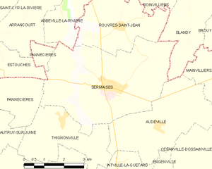
Sermaises
- commune in Loiret, France
- Country:

- Postal Code: 45300
- Coordinates: 48° 17' 47" N, 2° 12' 17" E


- GPS tracks (wikiloc): [Link]
- Area: 21.25 sq km
- Population: 1615
Nangeville
- former commune in Loiret, France
- Country:

- Postal Code: 45330
- Coordinates: 48° 18' 33" N, 2° 19' 19" E


- GPS tracks (wikiloc): [Link]
- Area: 8.59 sq km
- Population: 116
Labrosse
- former commune in Loiret, France
- Country:

- Postal Code: 45330
- Coordinates: 48° 14' 39" N, 2° 23' 32" E


- GPS tracks (wikiloc): [Link]
- Area: 4.09 sq km
- Population: 93


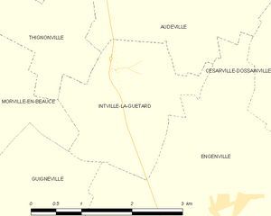
Intville-la-Guétard
- commune in Loiret, France
- Country:

- Postal Code: 45300
- Coordinates: 48° 15' 37" N, 2° 12' 48" E


- GPS tracks (wikiloc): [Link]
- Area: 4.88 sq km
- Population: 130
Morville-en-Beauce
- commune in Loiret, France
- Country:

- Postal Code: 45300
- Coordinates: 48° 15' 0" N, 2° 10' 21" E


- GPS tracks (wikiloc): [Link]
- Area: 11.02 sq km
- Population: 174


Orveau-Bellesauve
- former commune in Loiret, France
- Country:

- Postal Code: 45330
- Coordinates: 48° 16' 55" N, 2° 19' 44" E


- GPS tracks (wikiloc): [Link]
- Area: 15.8 sq km
- Population: 503


Mainvilliers
- former commune in Loiret, France
- Country:

- Postal Code: 45330
- Coordinates: 48° 18' 2" N, 2° 16' 46" E


- GPS tracks (wikiloc): [Link]
- Area: 10.3 sq km
- Population: 260


Coudray
- former commune in Loiret, France
- Country:

- Postal Code: 45330
- Coordinates: 48° 16' 19" N, 2° 22' 6" E


- GPS tracks (wikiloc): [Link]
- Area: 12.42 sq km
- Population: 401
Engenville
- commune in Loiret, France
- Country:

- Postal Code: 45300
- Coordinates: 48° 14' 17" N, 2° 14' 46" E


- GPS tracks (wikiloc): [Link]
- Area: 18.1 sq km
- Population: 567
- Web site: [Link]


Thignonville
- commune in Loiret, France
- Country:

- Postal Code: 45300
- Coordinates: 48° 16' 51" N, 2° 10' 24" E


- GPS tracks (wikiloc): [Link]
- Area: 9.16 sq km
- Population: 376


Malesherbes
- former commune in Loiret, France
- Country:

- Postal Code: 45330
- Coordinates: 48° 17' 47" N, 2° 24' 19" E


- GPS tracks (wikiloc): [Link]
- Area: 17.61 sq km
- Population: 6007
- Web site: [Link]
