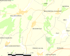
canton of Molliens-Dreuil (canton de Molliens-Dreuil)

- canton of France
- Country:

- Capital: Molliens-Dreuil
- Coordinates: 49° 53' 2" N, 2° 1' 12" E


- GPS tracks (wikiloc): [Link]
- Wikipedia en: wiki(en)
- Wikipedia: wiki(fr)
- Wikidata storage: Wikidata: Q1726257
- Freebase ID: [/m/03y88lh]
- INSEE canton code: [8026]
Includes regions:


Camps-en-Amiénois
- commune in Somme, France
- Country:
- Postal Code: 80540
- Coordinates: 49° 52' 48" N, 1° 58' 9" E
- GPS tracks (wikiloc): [Link]
- Area: 4.54 sq km
- Population: 181


Fresnoy-au-Val
- commune in Somme, France
- Country:
- Postal Code: 80710
- Coordinates: 49° 50' 6" N, 2° 3' 19" E
- GPS tracks (wikiloc): [Link]
- Area: 8.07 sq km
- Population: 245


Fluy
- commune in Somme, France
- Country:
- Postal Code: 80540
- Coordinates: 49° 51' 30" N, 2° 5' 50" E
- GPS tracks (wikiloc): [Link]
- Area: 6.38 sq km
- Population: 317


Guignemicourt
- commune in Somme, France
- Country:
- Postal Code: 80540
- Coordinates: 49° 52' 12" N, 2° 10' 29" E
- GPS tracks (wikiloc): [Link]
- Area: 4.48 sq km
- Population: 301
- Web site: [Link]


Airaines
- commune in Somme, France
- Country:
- Postal Code: 80270
- Coordinates: 49° 57' 54" N, 1° 56' 36" E
- GPS tracks (wikiloc): [Link]
- AboveSeaLevel: 49 м m
- Area: 24.88 sq km
- Population: 2369
- Web site: [Link]


Laleu
- commune in Somme, France
- Country:
- Postal Code: 80270
- Coordinates: 49° 56' 29" N, 1° 55' 57" E
- GPS tracks (wikiloc): [Link]
- Area: 1.56 sq km
- Population: 100


Molliens-Dreuil
- commune in Somme, France
- Country:
- Postal Code: 80540
- Coordinates: 49° 53' 1" N, 2° 1' 9" E
- GPS tracks (wikiloc): [Link]
- AboveSeaLevel: 49 м m
- Area: 22.8 sq km
- Population: 901


Montagne-Fayel
- commune in Somme, France
- Country:
- Postal Code: 80540
- Coordinates: 49° 54' 52" N, 1° 58' 51" E
- GPS tracks (wikiloc): [Link]
- Area: 6.93 sq km
- Population: 159


Métigny
- commune in Somme, France
- Country:
- Postal Code: 80270
- Coordinates: 49° 56' 43" N, 1° 55' 39" E
- GPS tracks (wikiloc): [Link]
- Area: 6.68 sq km
- Population: 124


Avelesges
- commune in Somme, France
- Country:
- Postal Code: 80270
- Coordinates: 49° 54' 59" N, 1° 56' 9" E
- GPS tracks (wikiloc): [Link]
- Area: 4.87 sq km
- Population: 59


Oissy
- commune in Somme, France
- Country:
- Postal Code: 80540
- Coordinates: 49° 54' 17" N, 2° 3' 2" E
- GPS tracks (wikiloc): [Link]
- Area: 5.52 sq km
- Population: 228


Saisseval
- commune in Somme, France
- Country:
- Postal Code: 80540
- Coordinates: 49° 53' 40" N, 2° 6' 45" E
- GPS tracks (wikiloc): [Link]
- Area: 7.32 sq km
- Population: 240


Bovelles
- commune in Somme, France
- Country:
- Postal Code: 80540
- Coordinates: 49° 52' 57" N, 2° 8' 43" E
- GPS tracks (wikiloc): [Link]
- Area: 6.87 sq km
- Population: 435
- Web site: [Link]


Pissy
- commune in Somme, France
- Country:
- Postal Code: 80540
- Coordinates: 49° 51' 43" N, 2° 7' 50" E
- GPS tracks (wikiloc): [Link]
- Area: 6.63 sq km
- Population: 279
- Web site: [Link]


Clairy-Saulchoix
- commune in Somme, France
- Country:
- Postal Code: 80540
- Coordinates: 49° 51' 21" N, 2° 10' 45" E
- GPS tracks (wikiloc): [Link]
- Area: 6.52 sq km
- Population: 369
- Web site: [Link]
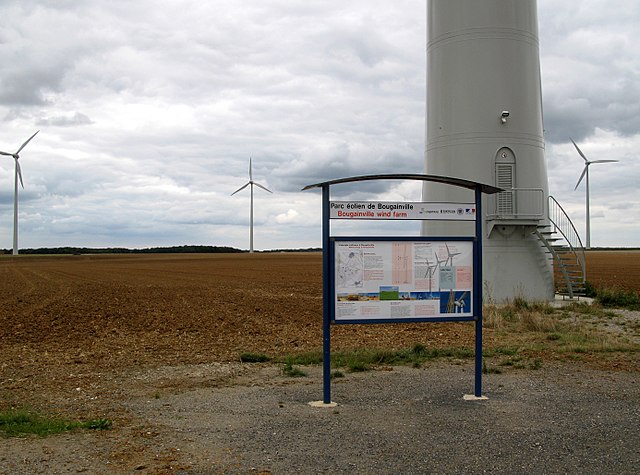
Bougainville
- commune in Somme, France
- Country:
- Postal Code: 80540
- Coordinates: 49° 52' 12" N, 2° 2' 30" E
- GPS tracks (wikiloc): [Link]
- Area: 10.21 sq km
- Population: 447
- Web site: [Link]


Creuse
- commune in Somme, France
- Country:
- Postal Code: 80480
- Coordinates: 49° 50' 22" N, 2° 9' 52" E
- GPS tracks (wikiloc): [Link]
- Area: 5.02 sq km
- Population: 190
- Web site: [Link]


Quesnoy-sur-Airaines
- commune in Somme, France
- Country:
- Postal Code: 80270
- Coordinates: 49° 57' 22" N, 1° 59' 27" E
- GPS tracks (wikiloc): [Link]
- Area: 16.14 sq km
- Population: 444
- Web site: [Link]


Revelles
- commune in Somme, France
- Country:
- Postal Code: 80540
- Coordinates: 49° 50' 56" N, 2° 7' 16" E
- GPS tracks (wikiloc): [Link]
- Area: 14.41 sq km
- Population: 534
- Web site: [Link]

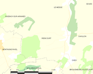
Riencourt
- commune in Somme, France
- Country:
- Postal Code: 80310
- Coordinates: 49° 55' 19" N, 2° 2' 57" E
- GPS tracks (wikiloc): [Link]
- Area: 10.16 sq km
- Population: 183


Quevauvillers
- commune in Somme, France
- Country:
- Postal Code: 80710
- Coordinates: 49° 49' 25" N, 2° 5' 2" E
- GPS tracks (wikiloc): [Link]
- Area: 8.82 sq km
- Population: 1115
- Web site: [Link]


Briquemesnil-Floxicourt
- commune in Somme, France
- Country:
- Postal Code: 80540
- Coordinates: 49° 53' 4" N, 2° 5' 11" E
- GPS tracks (wikiloc): [Link]
- Area: 7.35 sq km
- Population: 220


Saint-Aubin-Montenoy
- commune in Somme, France
- Country:
- Postal Code: 80540
- Coordinates: 49° 50' 48" N, 1° 59' 44" E
- GPS tracks (wikiloc): [Link]
- Area: 10.41 sq km
- Population: 229

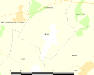
Seux
- commune in Somme, France
- Country:
- Postal Code: 80540
- Coordinates: 49° 52' 24" N, 2° 6' 25" E
- GPS tracks (wikiloc): [Link]
- Area: 3.53 sq km
- Population: 171


Tailly
- commune in Somme, France
- Country:
- Postal Code: 80270
- Coordinates: 49° 55' 50" N, 1° 56' 49" E
- GPS tracks (wikiloc): [Link]
- AboveSeaLevel: 47 м m
- Area: 4.05 sq km
- Population: 59


Warlus
- commune in Somme, France
- Country:
- Postal Code: 80270
- Coordinates: 49° 55' 26" N, 1° 56' 40" E
- GPS tracks (wikiloc): [Link]
- Area: 8.12 sq km
- Population: 226


Bettencourt-Rivière
- commune in Somme, France
- Country:
- Postal Code: 80270
- Coordinates: 49° 59' 49" N, 1° 58' 38" E
- GPS tracks (wikiloc): [Link]
- Area: 7.38 sq km
- Population: 217