canton of Saint-Jean-d'Angély (canton de Saint-Jean-d'Angély)

- canton of France
- Country:

- Capital: Saint-Jean-d'Angély
- Coordinates: 45° 57' 15" N, 0° 30' 48" E


- GPS tracks (wikiloc): [Link]
- Population: 26864
- Wikipedia en: wiki(en)
- Wikipedia: wiki(fr)
- Wikidata storage: Wikidata: Q1727217
- Library of Congress authority ID: Alt: [n83228627]
- INSEE canton code: [1718]
Includes regions:

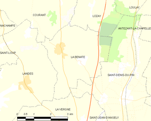
La Benâte
- former commune in Charente-Maritime, France
- Country:
- Postal Code: 17400
- Coordinates: 46° 0' 44" N, 0° 34' 18" E
- GPS tracks (wikiloc): [Link]
- Area: 11.07 sq km
- Population: 420


Antezant-la-Chapelle
- commune in Charente-Maritime, France
- Country:
- Postal Code: 17400
- Coordinates: 45° 58' 57" N, 0° 27' 23" E
- GPS tracks (wikiloc): [Link]
- AboveSeaLevel: 30 м m
- Area: 18.63 sq km
- Population: 356


Bignay
- commune in Charente-Maritime, France
- Country:
- Postal Code: 17400
- Coordinates: 45° 54' 58" N, 0° 36' 6" E
- GPS tracks (wikiloc): [Link]
- Area: 8.73 sq km
- Population: 414


Asnières-la-Giraud
- commune in Charente-Maritime, France
- Country:
- Postal Code: 17400
- Coordinates: 45° 53' 23" N, 0° 31' 16" E
- GPS tracks (wikiloc): [Link]
- Area: 18.64 sq km
- Population: 1020


La Vergne
- commune in Charente-Maritime, France
- Country:
- Postal Code: 17400
- Coordinates: 45° 57' 44" N, 0° 33' 53" E
- GPS tracks (wikiloc): [Link]
- Area: 13.97 sq km
- Population: 592
- Web site: [Link]


Les Églises-d'Argenteuil
- commune in Charente-Maritime, France
- Country:
- Postal Code: 17400
- Coordinates: 45° 58' 25" N, 0° 25' 58" E
- GPS tracks (wikiloc): [Link]
- Area: 14.29 sq km
- Population: 522


Mazeray
- commune in Charente-Maritime, France
- Country:
- Postal Code: 17400
- Coordinates: 45° 54' 30" N, 0° 33' 49" E
- GPS tracks (wikiloc): [Link]
- Area: 19.38 sq km
- Population: 913


Vervant
- commune in Charente-Maritime, France
- Country:
- Postal Code: 17400
- Coordinates: 45° 58' 25" N, 0° 27' 16" E
- GPS tracks (wikiloc): [Link]
- Area: 5.62 sq km
- Population: 241


Saint-Julien-de-l'Escap
- commune in Charente-Maritime, France
- Country:
- Postal Code: 17400
- Coordinates: 45° 56' 1" N, 0° 29' 24" E
- GPS tracks (wikiloc): [Link]
- Area: 8.68 sq km
- Population: 913


Poursay-Garnaud
- commune in Charente-Maritime, France
- Country:
- Postal Code: 17400
- Coordinates: 45° 57' 10" N, 0° 27' 38" E
- GPS tracks (wikiloc): [Link]
- Area: 5.22 sq km
- Population: 318


Courcelles
- commune in Charente-Maritime, France
- Country:
- Postal Code: 17400
- Coordinates: 45° 57' 21" N, 0° 28' 40" E
- GPS tracks (wikiloc): [Link]
- AboveSeaLevel: 20 м m
- Area: 6.77 sq km
- Population: 478


Saint-Denis-du-Pin
- former commune in Charente-Maritime, France
- Country:
- Postal Code: 17400
- Coordinates: 45° 59' 10" N, 0° 31' 17" E
- GPS tracks (wikiloc): [Link]
- AboveSeaLevel: 43 м m
- Area: 19.16 sq km
- Population: 751

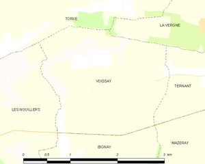
Voissay
- commune in Charente-Maritime, France
- Country:
- Postal Code: 17400
- Coordinates: 45° 57' 8" N, 0° 36' 20" E
- GPS tracks (wikiloc): [Link]
- Area: 5.06 sq km
- Population: 161


Landes
- commune in Charente-Maritime, France
- Country:
- Postal Code: 17380
- Coordinates: 45° 59' 32" N, 0° 35' 51" E
- GPS tracks (wikiloc): [Link]
- Area: 16.05 sq km
- Population: 612

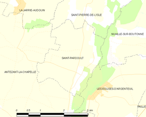
Saint-Pardoult
- commune in Charente-Maritime, France
- Country:
- Postal Code: 17400
- Coordinates: 46° 0' 0" N, 0° 27' 0" E
- GPS tracks (wikiloc): [Link]
- Area: 5.6 sq km
- Population: 233
- Web site: [Link]


Ternant
- commune in Charente-Maritime, France
- Country:
- Postal Code: 17400
- Coordinates: 45° 56' 58" N, 0° 34' 27" E
- GPS tracks (wikiloc): [Link]
- Area: 5.61 sq km
- Population: 374
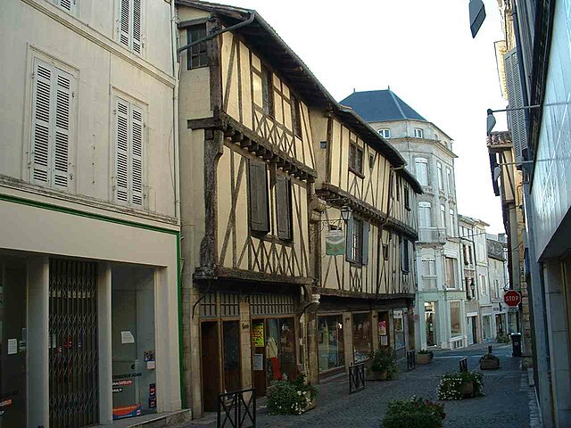

Saint-Jean-d'Angély
- commune in Charente-Maritime, France
- Country:
- Postal Code: 17400
- Coordinates: 45° 56' 39" N, 0° 31' 16" E
- GPS tracks (wikiloc): [Link]
- Area: 18.78 sq km
- Population: 7106
- Web site: [Link]

Fontenet
- commune in Charente-Maritime, France
- Country:
- Postal Code: 17400
- Coordinates: 45° 54' 45" N, 0° 27' 13" E
- GPS tracks (wikiloc): [Link]
- Area: 10.27 sq km
- Population: 409


Varaize
- commune in Charente-Maritime, France
- Country:
- Postal Code: 17400
- Coordinates: 45° 55' 21" N, 0° 25' 21" E
- GPS tracks (wikiloc): [Link]
- Area: 20.48 sq km
- Population: 559
- Web site: [Link]