canton of Villers-Bocage (canton de Villers-Bocage)
- Calvados Department
- Country:

- Capital: Villers-Bocage
- Coordinates: 49° 4' 47" N, 0° 39' 19" E


- GPS tracks (wikiloc): [Link]
- Wikipedia en: wiki(en)
- Wikipedia: wiki(fr)
- Wikidata storage: Wikidata: Q1727921
- INSEE canton code: [1437]
Includes regions:

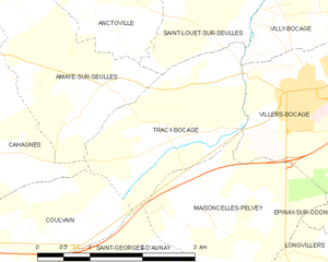
Tracy-Bocage
- commune in Calvados, France
- Country:
- Postal Code: 14310
- Coordinates: 49° 4' 22" N, 0° 41' 29" E
- GPS tracks (wikiloc): [Link]
- Area: 5.24 sq km
- Population: 308


Villy-Bocage
- commune in Calvados, France
- Country:
- Postal Code: 14310
- Coordinates: 49° 5' 43" N, 0° 38' 33" E
- GPS tracks (wikiloc): [Link]
- Area: 11.39 sq km
- Population: 800


Villers-Bocage
- commune in Calvados, France
- Country:
- Postal Code: 14310
- Coordinates: 49° 4' 44" N, 0° 39' 23" E
- GPS tracks (wikiloc): [Link]
- Area: 5.76 sq km
- Population: 3105
- Web site: [Link]

Saint-Louet-sur-Seulles
- commune in Calvados, France
- Country:
- Postal Code: 14310
- Coordinates: 49° 5' 48" N, 0° 40' 1" E
- GPS tracks (wikiloc): [Link]
- Area: 4.33 sq km
- Population: 153


Tournay-sur-Odon
- former commune in Calvados, France
- Country:
- Postal Code: 14310
- Coordinates: 49° 5' 28" N, 0° 35' 16" E
- GPS tracks (wikiloc): [Link]
- Area: 6.93 sq km
- Population: 357