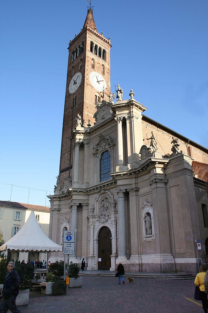
Cassano d'Adda (Cassano d'Adda)
.svg)
- Italian comune
 Hiking in Cassano d'Adda
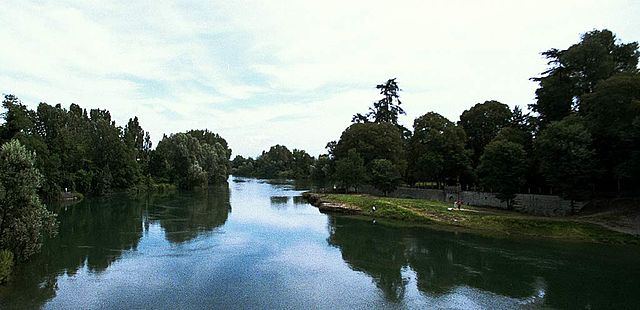
Cassano d'Adda is a charming town located in the Lombardy region of Italy, nestled along the Adda River. It's not only a picturesque area with historical significance but also offers some lovely opportunities for hiking and outdoor activities.
Hiking Opportunities:
-
Adda River Path (Sentiero del Fiume Adda):
- One of the most popular hiking routes in the area is along the banks of the Adda River. This path is part of a network of trails that extend through the surrounding countryside, showcasing scenic views, lush vegetation, and opportunities to observe local wildlife.
-
Parco Adda Nord:
- This regional park is accessible from Cassano d'Adda and features diverse landscapes, including forests, riverside paths, and historical sites. There are several marked trails perfect for hikers of varying skill levels. The park is also great for birdwatching and enjoying the natural beauty of the region.
-
Nearby Hikes:
- If you’re willing to travel a bit further, you can explore other trails in the area, such as those in the nearby Bergamo hills or even reach out towards the foothills of the Alps. These hikes can be more challenging and offer stunning panoramic views.
Tips for Hiking in Cassano d'Adda:
- Best Time to Hike: Spring (April to June) and early autumn (September to October) are ideal for hiking, with mild temperatures and beautiful scenery.
- What to Bring: Always carry enough water, snacks, a map, and appropriate clothing for the weather. A good pair of hiking shoes is essential, especially if you're going on rugged paths.
- Wildlife and Nature: Be mindful of the local wildlife, and enjoy the diverse flora and fauna. Remember to stick to the trails to minimize your impact on the environment.
- Explore the Town: Don’t forget to take some time to explore Cassano d'Adda itself, which has historical sites, including old churches and Villas like Villa Borromeo.
Safety Considerations:
- Always let someone know your hiking plans and estimated return time.
- Check the weather forecast before heading out.
- Stay within marked trails to ensure your safety and protect the environment.
Cassano d'Adda offers a wonderful blend of cultural heritage and natural beauty, making it an excellent destination for hiking enthusiasts. Enjoy the trails!
- Country:

- Postal Code: 20062
- Local Dialing Code: 0363
- Licence Plate Code: MI
- Coordinates: 45° 32' 0" N, 9° 31' 0" E


- GPS tracks (wikiloc): [Link]
- AboveSeaLevel: 133 м m
- Area: 18.6 sq km
- Population: 18911
- Web site: http://www.comune.cassanospinola.al.it
- Wikipedia en: wiki(en)
- Wikipedia: wiki(it)
- Wikidata storage: Wikidata: Q42613
- Wikipedia Commons Gallery: [Link]
- Wikipedia Commons Category: [Link]
- Freebase ID: [/m/079gn8]
- GeoNames ID: Alt: [6540333]
- VIAF ID: Alt: [138577609]
- OSM relation ID: [45178]
- Quora topic ID: [Cassano-dAdda]
- UN/LOCODE: [ITCDD]
- ISTAT ID: 015059
- Italian cadastre code: C003
Shares border with regions:


Casirate d'Adda
- Italian comune
Hiking in Casirate d'Adda
Casirate d'Adda is a charming town located in the province of Bergamo in Lombardy, Italy. While it may not be as famous for hiking as some of the larger national parks or mountainous regions in the area, there are still opportunities for outdoor activities and enjoying nature in and around the town....
- Country:
- Postal Code: 24040
- Local Dialing Code: 0363
- Licence Plate Code: BG
- Coordinates: 45° 30' 0" N, 9° 34' 0" E
- GPS tracks (wikiloc): [Link]
- AboveSeaLevel: 114 м m
- Area: 10.17 sq km
- Population: 4120
- Web site: [Link]


Fara Gera d'Adda
- Italian comune
Hiking in Fara Gera d'Adda
Fara Gera d'Adda is a charming town located in the Lombardy region of Italy, near the Adda River. While it may not be as well-known as some larger hiking destinations, it offers a variety of outdoor activities and scenic trails that can be appealing to hikers....
- Country:
- Postal Code: 24045
- Local Dialing Code: 0363
- Licence Plate Code: BG
- Coordinates: 45° 33' 0" N, 9° 32' 0" E
- GPS tracks (wikiloc): [Link]
- AboveSeaLevel: 131 м m
- Area: 10.79 sq km
- Population: 8043
- Web site: [Link]

Treviglio
- Italian comune
Hiking in Treviglio
Treviglio is located in the Lombardy region of northern Italy, not far from Milan. While Treviglio itself may not be a major hiking destination, it serves as a good base for accessing nearby natural areas and hiking trails in the surrounding region....
- Country:
- Postal Code: 24047
- Local Dialing Code: 0363
- Licence Plate Code: BG
- Coordinates: 45° 31' 17" N, 9° 35' 34" E
- GPS tracks (wikiloc): [Link]
- AboveSeaLevel: 125 м m
- Area: 32.22 sq km
- Population: 29815
- Web site: [Link]


Truccazzano
- Italian comune
Hiking in Truccazzano
Truccazzano, a small municipality located in the Lombardy region of Italy, offers a picturesque setting for hiking enthusiasts. While it may not be as widely known as some of the larger national parks or mountainous regions in Italy, it still has its unique charm and opportunities for exploration....
- Country:
- Postal Code: 20060
- Local Dialing Code: 02
- Licence Plate Code: MI
- Coordinates: 45° 29' 0" N, 9° 28' 0" E
- GPS tracks (wikiloc): [Link]
- AboveSeaLevel: 108 м m
- Area: 21.98 sq km
- Population: 5934
- Web site: [Link]


Pozzuolo Martesana
- Italian comune
Hiking in Pozzuolo Martesana
Pozzuolo Martesana, located in the Lombardy region of Italy, is predominantly a residential area. While it may not be as famous as some of Italy's larger national parks or hiking destinations, it offers various opportunities for hiking and outdoor activities in the surrounding regions....
- Country:
- Postal Code: 20060
- Local Dialing Code: 02
- Licence Plate Code: MI
- Coordinates: 45° 31' 0" N, 9° 27' 0" E
- GPS tracks (wikiloc): [Link]
- AboveSeaLevel: 121 м m
- Area: 12.14 sq km
- Population: 8471
- Web site: [Link]
Pozzo d'Adda
- Italian comune
Hiking in Pozzo d'Adda
Pozzo d'Adda, located in the Lombardy region of Italy, is not as widely known for hiking as some other areas, but it does lie along the Adda River and is surrounded by beautiful natural landscapes. Here are some key points to consider if you're thinking about hiking in this area:...
- Country:
- Postal Code: 20060
- Local Dialing Code: 02
- Licence Plate Code: MI
- Coordinates: 45° 35' 0" N, 9° 30' 0" E
- GPS tracks (wikiloc): [Link]
- AboveSeaLevel: 164 м m
- Area: 4.16 sq km
- Population: 6068
- Web site: [Link]

Vaprio d'Adda
- Italian comune
Hiking in Vaprio d'Adda
Vaprio d'Adda is a charming town located in the Lombardy region of Italy, situated along the Adda River. It's an excellent destination for hiking enthusiasts due to its picturesque landscapes and natural beauty. Here are some key points about hiking in the area:...
- Country:
- Postal Code: 20069
- Local Dialing Code: 02
- Licence Plate Code: MI
- Coordinates: 45° 34' 0" N, 9° 32' 0" E
- GPS tracks (wikiloc): [Link]
- AboveSeaLevel: 161 м m
- Area: 7.15 sq km
- Population: 8972
- Web site: [Link]


Rivolta d'Adda
- Italian comune
Hiking in Rivolta d'Adda
Rivolta d'Adda is a charming town located in the Lombardy region of Italy, near the Adda River. While it may not be as well-known for hiking as some other destinations in Italy, it offers a variety of outdoor activities and scenic trails that are ideal for those looking to enjoy nature....
- Country:
- Postal Code: 26027
- Local Dialing Code: 0363
- Licence Plate Code: CR
- Coordinates: 45° 28' 0" N, 9° 31' 0" E
- GPS tracks (wikiloc): [Link]
- AboveSeaLevel: 101 м m
- Area: 30.4 sq km
- Population: 8133
- Web site: [Link]


Inzago
- Italian comune
Hiking in Inzago
Inzago is a small town located in the Lombardy region of northern Italy, within the Metropolitan City of Milan. While Inzago itself may not be a widely recognized hiking destination, it is surrounded by scenic areas that can offer opportunities for walking and hiking....
- Country:
- Postal Code: 20065
- Local Dialing Code: 02
- Licence Plate Code: MI
- Coordinates: 45° 32' 0" N, 9° 29' 0" E
- GPS tracks (wikiloc): [Link]
- AboveSeaLevel: 137 м m
- Area: 12.21 sq km
- Population: 10947
- Web site: [Link]