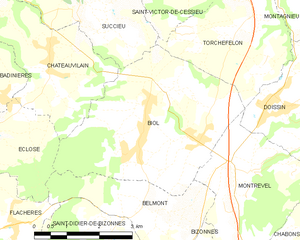
Châteauvilain (Châteauvilain)

- commune in Isère, France
 Hiking in Châteauvilain
Châteauvilain, located in the beautiful region of France, is known for its picturesque landscapes and hiking opportunities. While specific trails and conditions may vary, here are some general insights into hiking in the area:
1. :
- The area often features a variety of trails that offer stunning views of the surrounding countryside, forests, and possibly even historical landmarks, depending on the specific routes you choose.
2. :
- Trails in and around Châteauvilain can range from easy walks suitable for families to more challenging hikes for experienced hikers. Be sure to check local maps or guides for difficulty ratings.
3. :
- Hiking in Châteauvilain provides opportunities to observe local wildlife and flora. Depending on the season, you may encounter various birds, plants, and other natural wonders.
4. :
- As with many regions in France, some hiking trails may pass by historical sites or landmarks that can enrich your hiking experience. Keep an eye out for informational signs along the way.
5. :
- The best times for hiking typically tend to be in the spring and autumn when the weather is milder. Summer can be hot, and winter might present snow-covered trails. Always check local weather conditions before heading out.
6. :
- Ensure you are well-prepared with good hiking shoes, adequate water, and a map or reliable GPS. Inform someone of your hiking plans if you're going on remote trails.
7. :
- Be sure to respect local regulations regarding trail use, including keeping dogs on leashes, sticking to marked paths, and carrying out any waste.
8. :
- Local tourist offices can provide maps, trail recommendations, and up-to-date information about trail conditions.
Before heading out, I recommend checking various hiking forums or local resources for up-to-date information specific to the trails in and around Châteauvilain, as conditions and available routes can change. Happy hiking!
- Country:

- Postal Code: 38300
- Coordinates: 45° 31' 0" N, 5° 19' 48" E


- GPS tracks (wikiloc): [Link]
- AboveSeaLevel: 500 м m
- Area: 8.82 sq km
- Population: 701
- Web site: http://www.chateauvilain.fr
- Wikipedia en: wiki(en)
- Wikipedia: wiki(fr)
- Wikidata storage: Wikidata: Q574036
- Wikipedia Commons Category: [Link]
- Freebase ID: [/m/03nvgq1]
- GeoNames ID: Alt: [6448756]
- SIREN number: [213800915]
- BnF ID: [15257918g]
- INSEE municipality code: 38091
Shares border with regions:

Biol
- commune in Isère, France
Hiking in Biol
Biol is a charming village located in the Isère department of the Auvergne-Rhône-Alpes region in southeastern France. It's a great destination for hikers due to its proximity to the beautiful Vercors massif and the Chartreuse mountain range. Here are some highlights and tips for hiking in and around Biol:...
- Country:
- Postal Code: 38690
- Coordinates: 45° 29' 30" N, 5° 23' 7" E
- GPS tracks (wikiloc): [Link]
- Area: 15.51 sq km
- Population: 1398
- Web site: [Link]


Les Éparres
- commune in Isère, France
Hiking in Les Éparres
Les Éparres, located in the southeastern region of France near the Vercors Massif, offers beautiful landscapes and a variety of hiking trails suitable for different skill levels. The area is characterized by its stunning views, diverse flora and fauna, and the unique geological features of the region....
- Country:
- Postal Code: 38300
- Coordinates: 45° 32' 1" N, 5° 17' 34" E
- GPS tracks (wikiloc): [Link]
- Area: 7.95 sq km
- Population: 987
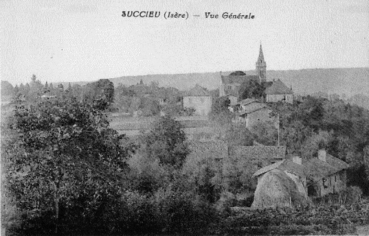
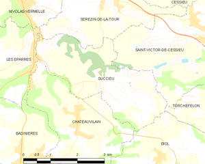
Succieu
- commune in Isère, France
Hiking in Succieu
Succieu is a charming village located in the Auvergne-Rhône-Alpes region of France, surrounded by beautiful landscapes that make it an appealing destination for hiking enthusiasts. While it may not be as well-known as some larger hiking areas, it offers a variety of trails that showcase the natural beauty of the region....
- Country:
- Postal Code: 38300
- Coordinates: 45° 31' 40" N, 5° 20' 20" E
- GPS tracks (wikiloc): [Link]
- Area: 8.35 sq km
- Population: 728
- Web site: [Link]