Chalain-d'Uzore (Chalain-d'Uzore)

- commune in Loire, France
- Country:

- Postal Code: 42600
- Coordinates: 45° 40' 21" N, 4° 4' 14" E


- GPS tracks (wikiloc): [Link]
- Area: 8.03 sq km
- Population: 535
- Wikipedia en: wiki(en)
- Wikipedia: wiki(fr)
- Wikidata storage: Wikidata: Q1068632
- Wikipedia Commons Category: [Link]
- Freebase ID: [/m/03nw5hc]
- Freebase ID: [/m/03nw5hc]
- GeoNames ID: Alt: [6448973]
- GeoNames ID: Alt: [6448973]
- SIREN number: [214200370]
- SIREN number: [214200370]
- BnF ID: [15259607g]
- BnF ID: [15259607g]
- INSEE municipality code: 42037
- INSEE municipality code: 42037
Shares border with regions:


Saint-Paul-d'Uzore
- commune in Loire, France
- Country:
- Postal Code: 42600
- Coordinates: 45° 40' 41" N, 4° 4' 50" E
- GPS tracks (wikiloc): [Link]
- Area: 9.51 sq km
- Population: 161


Marcilly-le-Châtel
- commune in Loire, France
- Country:
- Postal Code: 42130
- Coordinates: 45° 41' 42" N, 4° 2' 14" E
- GPS tracks (wikiloc): [Link]
- AboveSeaLevel: 420 м m
- Area: 16.32 sq km
- Population: 1385
- Web site: [Link]
Pralong
- commune in Loire, France
- Country:
- Postal Code: 42600
- Coordinates: 45° 39' 56" N, 4° 1' 49" E
- GPS tracks (wikiloc): [Link]
- Area: 8.03 sq km
- Population: 868

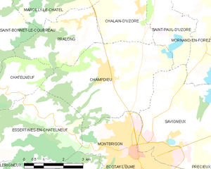
Champdieu
- commune in Loire, France
- Country:
- Postal Code: 42600
- Coordinates: 45° 38' 41" N, 4° 2' 43" E
- GPS tracks (wikiloc): [Link]
- Area: 18.2 sq km
- Population: 1856
- Web site: [Link]


Montverdun
- commune in Loire, France
- Country:
- Postal Code: 42130
- Coordinates: 45° 42' 54" N, 4° 4' 1" E
- GPS tracks (wikiloc): [Link]
- Area: 16.52 sq km
- Population: 1273