Charbonnières (Charbonnières)

- commune in Eure-et-Loir, France
- Country:

- Postal Code: 28330
- Coordinates: 48° 11' 32" N, 0° 56' 10" E


- GPS tracks (wikiloc): [Link]
- Area: 20.91 sq km
- Population: 255
- Wikipedia en: wiki(en)
- Wikipedia: wiki(fr)
- Wikidata storage: Wikidata: Q1075359
- Wikipedia Commons Category: [Link]
- Freebase ID: [/m/03nqsmg]
- GeoNames ID: Alt: [6448026]
- SIREN number: [212800809]
- BnF ID: [15254011v]
- INSEE municipality code: 28080
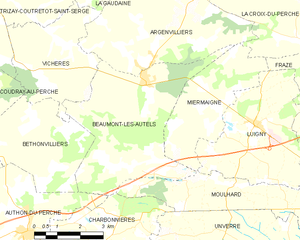
Shares border with regions:

Beaumont-les-Autels
- commune in Eure-et-Loir, France
- Country:
- Postal Code: 28420
- Coordinates: 48° 15' 24" N, 0° 57' 33" E
- GPS tracks (wikiloc): [Link]
- Area: 20.98 sq km
- Population: 411

Soizé
- commune in Eure-et-Loir, France
- Country:
- Postal Code: 28330
- Coordinates: 48° 10' 3" N, 0° 53' 14" E
- GPS tracks (wikiloc): [Link]
- Area: 18.13 sq km
- Population: 298


Unverre
- commune in Eure-et-Loir, France
- Country:
- Postal Code: 28160
- Coordinates: 48° 11' 58" N, 1° 5' 36" E
- GPS tracks (wikiloc): [Link]
- Area: 62.33 sq km
- Population: 1223
- Web site: [Link]