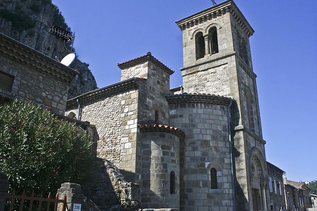
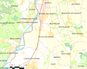
Charmes-sur-Rhône (Charmes-sur-Rhône)
- commune in Ardèche, France
 Hiking in Charmes-sur-Rhône
Charmes-sur-Rhône is a charming village located in the Auvergne-Rhône-Alpes region of France, known for its scenic landscapes and natural beauty. Hiking in this area offers a mix of serene views, lovely trails, and a chance to immerse yourself in nature. Here are some aspects to consider if you're planning a hiking trip in Charmes-sur-Rhône:
Trails and Routes
-
Local Trails: There are several trails that cater to different hiking levels, ranging from easy walks for families to more challenging routes for experienced hikers. The surrounding hills and the Rhône River create beautiful hiking environments.
-
Sentier de Grande Randonnée (GR): The nearby GR routes, which are long-distance hiking paths, can be accessed for those wanting a more extensive hiking experience. The GR42 route, among others, passes through this region, offering stunning vistas.
-
Nearby Natural Parks: The region is close to the Pilat Regional Natural Park and the Vercors Regional Natural Park, which provide an extensive network of hiking trails and opportunities for both day hikes and multi-day treks.
Scenery and Wildlife
- Natural Beauty: The trails often lead through vineyards, forests, and along the banks of the Rhône River, showcasing the diverse flora and fauna of the region.
- Wildlife: Keep an eye out for the local wildlife, which can include various birds, deer, and other small animals, depending on the time of year.
Seasons
- Spring and Summer: These are ideal seasons for hiking in Charmes-sur-Rhône, as the weather is typically mild and the landscapes are in full bloom.
- Autumn: Fall offers beautiful foliage, making hikes particularly scenic with vibrant colors.
- Winter: While hiking is still possible, be prepared for colder weather and potential snow in higher elevations.
Preparing for Your Hike
- Gear: Make sure to wear appropriate hiking footwear and bring necessary gear, including a map, water, and snacks. Some trails can be steep, so trekking poles may also be useful.
- Local Information: It's advisable to check local maps or consult with local hiking clubs or guides for the best trails and conditions.
Conclusion
Hiking around Charmes-sur-Rhône not only showcases the natural beauty of the region but also allows for exploration of the cultural heritage that surrounds it. Whether you're a seasoned hiker or a novice, there are plenty of trails to enjoy. Happy hiking!
- Country:

- Postal Code: 07800
- Coordinates: 44° 51' 49" N, 4° 50' 7" E


- GPS tracks (wikiloc): [Link]
- Area: 5.95 sq km
- Population: 2806
- Wikipedia en: wiki(en)
- Wikipedia: wiki(fr)
- Wikidata storage: Wikidata: Q323743
- Wikipedia Commons Category: [Link]
- Freebase ID: [/m/03g_h5g]
- GeoNames ID: Alt: [3026574]
- SIREN number: [210700555]
- VIAF ID: Alt: [139664638]
- Library of Congress authority ID: Alt: [n88187439]
- PACTOLS thesaurus ID: [pcrtIBhWTO8T3w]
- INSEE municipality code: 07055
Shares border with regions:
Soyons
- commune in Ardèche, France
Hiking in Soyons
Soyons is a charming village located in the Auvergne-Rhône-Alpes region of France, near the city of Valence. It offers a variety of scenic landscapes ideal for hiking enthusiasts. Here are some features and suggestions for hiking in and around Soyons:...
- Country:
- Postal Code: 07130
- Coordinates: 44° 53' 21" N, 4° 51' 1" E
- GPS tracks (wikiloc): [Link]
- Area: 7.9 sq km
- Population: 2211
- Web site: [Link]

Toulaud
- commune in Ardèche, France
Hiking in Toulaud
Toulaud is a picturesque commune located in the Auvergne-Rhône-Alpes region of France, specifically in the Ardèche department. It's known for its beautiful landscapes, rolling hills, and natural beauty, making it a great destination for hiking enthusiasts....
- Country:
- Postal Code: 07130
- Coordinates: 44° 53' 52" N, 4° 48' 59" E
- GPS tracks (wikiloc): [Link]
- Area: 34.73 sq km
- Population: 1674

Saint-Georges-les-Bains
- commune in Ardèche, France
Hiking in Saint-Georges-les-Bains
Saint-Georges-les-Bains is a picturesque commune located in the Auvergne-Rhône-Alpes region of France, nestled along the banks of the Rhone River. It's part of a broader area known for its natural beauty and outdoor recreational opportunities, making it a great spot for hiking enthusiasts....
- Country:
- Postal Code: 07800
- Coordinates: 44° 51' 40" N, 4° 48' 33" E
- GPS tracks (wikiloc): [Link]
- Area: 14.11 sq km
- Population: 2201
- Web site: [Link]

Étoile-sur-Rhône
- commune in Drôme, France
Hiking in Étoile-sur-Rhône
Étoile-sur-Rhône is a charming commune located in the Drôme department of southeastern France. Surrounded by the picturesque landscapes of the Rhône Valley, it serves as a great starting point for various hiking adventures....
- Country:
- Postal Code: 26800
- Coordinates: 44° 50' 13" N, 4° 53' 38" E
- GPS tracks (wikiloc): [Link]
- Area: 42.79 sq km
- Population: 5347
- Web site: [Link]