Chauray (Chauray)

- commune in Deux-Sèvres, France
- Country:

- Postal Code: 79180
- Coordinates: 46° 21' 38" N, 0° 22' 38" E


- GPS tracks (wikiloc): [Link]
- Area: 14.5 sq km
- Population: 6867
- Web site: http://www.ville-de-chauray.fr
- Wikipedia en: wiki(en)
- Wikipedia: wiki(fr)
- Wikidata storage: Wikidata: Q1084405
- Wikipedia Commons Category: [Link]
- Freebase ID: [/m/03mg284]
- GeoNames ID: Alt: [6451255]
- SIREN number: [217900810]
- BnF ID: [15276217c]
- VIAF ID: Alt: [132320345]
- GND ID: Alt: [10067153-6]
- INSEE municipality code: 79081
Shares border with regions:
La Crèche
- commune in Deux-Sèvres, France
- Country:
- Postal Code: 79260
- Coordinates: 46° 21' 39" N, 0° 18' 0" E
- GPS tracks (wikiloc): [Link]
- AboveSeaLevel: 67 м m
- Area: 34.5 sq km
- Population: 5524
- Web site: [Link]


Vouillé
- commune in Deux-Sèvres, France
- Country:
- Postal Code: 79230
- Coordinates: 46° 18' 59" N, 0° 21' 43" E
- GPS tracks (wikiloc): [Link]
- Area: 22.3 sq km
- Population: 3281

Saint-Gelais
- commune in Deux-Sèvres, France
- Country:
- Postal Code: 79410
- Coordinates: 46° 22' 57" N, 0° 23' 24" E
- GPS tracks (wikiloc): [Link]
- Area: 16.4 sq km
- Population: 2041

Niort
- commune in Deux-Sèvres, France
- Country:
- Postal Code: 79000
- Coordinates: 46° 19' 30" N, 0° 27' 44" E
- GPS tracks (wikiloc): [Link]
- AboveSeaLevel: 28 м m
- Area: 68.2 sq km
- Population: 58952
- Web site: [Link]

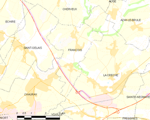
François
- commune in Deux-Sèvres, France
- Country:
- Postal Code: 79260
- Coordinates: 46° 23' 0" N, 0° 20' 25" E
- GPS tracks (wikiloc): [Link]
- Area: 9.39 sq km
- Population: 967