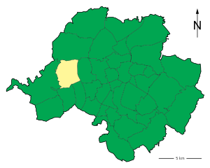
Rabenstein (Rabenstein)
- quarter of Chemnitz, Germany
Hiking in Chemnitz-Rabenstein offers a delightful blend of natural beauty and cultural landmarks in the region of Saxony, Germany. The area is characterized by picturesque landscapes, including forests, hills, and rivers, making it an appealing destination for both novice and experienced hikers.
Hiking Trails:
-
Hiking Routes:
- There are several marked hiking trails in and around Rabenstein, ranging from easy walks to more challenging routes. The trails often showcase the region's rich flora and fauna, including native wildlife.
-
Rabenstein Castle:
- A popular feature of the area is the historic Rabenstein Castle, which provides a great starting point for hikes. The castle is easily accessible and offers stunning views of the surrounding landscape.
-
Nature Reserves:
- The region is home to several nature reserves where hikers can immerse themselves in the tranquility of the Saxon nature. The Rabensteiner Wald is known for its dense forests and serene paths.
Additional Activities:
- Bird Watching: The forests and nature reserves are prime spots for birdwatching. Bring binoculars to enhance your experience.
- Picnicking: Many trails have scenic spots perfect for a rest and picnic, allowing hikers to enjoy the surroundings.
- Local Culture: Explore local traditions, cuisine, and crafts in nearby villages after your hike.
Practical Tips:
- Maps and Signage: Make sure to carry a map or use a hiking app, as trails can vary in marking quality.
- Weather Preparedness: The weather can change quickly. Wear appropriate layers and bring gear for rain, if necessary.
- Stay Hydrated and Nourished: Carry sufficient water and snacks, especially for longer hikes.
Conclusion:
Whether you're looking for a short scenic walk or a longer trekking experience, hiking in Chemnitz-Rabenstein can be a rewarding outdoor activity. The combination of natural beauty, historical sites, and the charm of the Saxon countryside makes it a wonderful destination for hikers. Enjoy your adventure!
- Country:

- Coordinates: 50° 49' 50" N, 12° 49' 25" E


- GPS tracks (wikiloc): [Link]
- Area: 7.01 sq km
- Wikidata storage: Wikidata: Q1069546
- Wikipedia Commons Category: [Link]
- VIAF ID: Alt: [245398359]
- OSM relation ID: [414874]
- archINFORM location ID: [44633]
- NKCR AUT ID: [ge879800]

