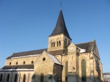
Courchamps (Courchamps)
- commune in Aisne, France
- Country:

- Postal Code: 02810
- Coordinates: 49° 6' 48" N, 3° 15' 54" E


- GPS tracks (wikiloc): [Link]
- Area: 2.72 sq km
- Population: 92
- Wikipedia en: wiki(en)
- Wikipedia: wiki(fr)
- Wikidata storage: Wikidata: Q605911
- Wikipedia Commons Category: [Link]
- Freebase ID: [/m/03m4dpc]
- Freebase ID: [/m/03m4dpc]
- GeoNames ID: Alt: [6424844]
- GeoNames ID: Alt: [6424844]
- SIREN number: [210202107]
- SIREN number: [210202107]
- INSEE municipality code: 02225
- INSEE municipality code: 02225
Shares border with regions:

Hautevesnes
- commune in Aisne, France
- Country:
- Postal Code: 02810
- Coordinates: 49° 6' 33" N, 3° 13' 55" E
- GPS tracks (wikiloc): [Link]
- Area: 7.29 sq km
- Population: 170

Licy-Clignon
- commune in Aisne, France
- Country:
- Postal Code: 02810
- Coordinates: 49° 6' 1" N, 3° 16' 26" E
- GPS tracks (wikiloc): [Link]
- Area: 4.09 sq km
- Population: 75
Monthiers
- commune in Aisne, France
- Country:
- Postal Code: 02400
- Coordinates: 49° 6' 12" N, 3° 17' 53" E
- GPS tracks (wikiloc): [Link]
- Area: 7.37 sq km
- Population: 158

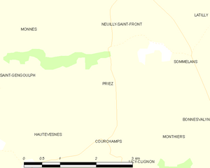
Priez
- commune in Aisne, France
- Country:
- Postal Code: 02470
- Coordinates: 49° 8' 13" N, 3° 15' 46" E
- GPS tracks (wikiloc): [Link]
- Area: 4.93 sq km
- Population: 48