Cronce (Cronce)

- commune in Haute-Loire, France
- Country:

- Postal Code: 43300
- Coordinates: 45° 5' 33" N, 3° 21' 38" E


- GPS tracks (wikiloc): [Link]
- Area: 16.15 sq km
- Population: 83
- Wikipedia en: wiki(en)
- Wikipedia: wiki(fr)
- Wikidata storage: Wikidata: Q1065910
- Wikipedia Commons Category: [Link]
- Freebase ID: [/m/03ntm85]
- GeoNames ID: Alt: [6449056]
- SIREN number: [214300824]
- BnF ID: [15259987s]
- INSEE municipality code: 43082
Shares border with regions:


Chastel
- commune in Haute-Loire, France
- Country:
- Postal Code: 43300
- Coordinates: 45° 5' 0" N, 3° 19' 22" E
- GPS tracks (wikiloc): [Link]
- Area: 27.69 sq km
- Population: 132
Arlet
- commune in Haute-Loire, France
- Country:
- Postal Code: 43380
- Coordinates: 45° 6' 58" N, 3° 25' 9" E
- GPS tracks (wikiloc): [Link]
- Area: 5.78 sq km
- Population: 25
Pinols
- commune in Haute-Loire, France
- Country:
- Postal Code: 43300
- Coordinates: 45° 3' 6" N, 3° 24' 49" E
- GPS tracks (wikiloc): [Link]
- Area: 34.92 sq km
- Population: 200
Ferrussac
- commune in Haute-Loire, France
- Country:
- Postal Code: 43300
- Coordinates: 45° 5' 34" N, 3° 24' 3" E
- GPS tracks (wikiloc): [Link]
- Area: 17.08 sq km
- Population: 81

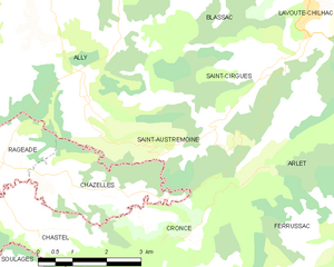
Saint-Austremoine
- commune in Haute-Loire, France
- Country:
- Postal Code: 43380
- Coordinates: 45° 7' 13" N, 3° 22' 11" E
- GPS tracks (wikiloc): [Link]
- Area: 11.55 sq km
- Population: 43
Chazelles
- commune in Cantal, France
- Country:
- Postal Code: 15500
- Coordinates: 45° 6' 13" N, 3° 20' 11" E
- GPS tracks (wikiloc): [Link]
- AboveSeaLevel: 976 м m
- Area: 6.28 sq km
- Population: 39