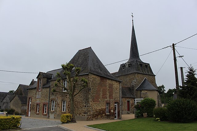
Cuillé (Cuillé)

- commune in Mayenne, France
- Country:

- Postal Code: 53540
- Coordinates: 47° 58' 15" N, 1° 7' 7" E


- GPS tracks (wikiloc): [Link]
- Area: 21.66 sq km
- Population: 909
- Wikipedia en: wiki(en)
- Wikipedia: wiki(fr)
- Wikidata storage: Wikidata: Q1003645
- Wikipedia Commons Category: [Link]
- Freebase ID: [/m/03qdd7d]
- Freebase ID: [/m/03qdd7d]
- SIREN number: [215300880]
- SIREN number: [215300880]
- BnF ID: [152638816]
- BnF ID: [152638816]
- INSEE municipality code: 53088
- INSEE municipality code: 53088
Shares border with regions:


Gennes-sur-Seiche
- commune in Ille-et-Vilaine, France
- Country:
- Postal Code: 35370
- Coordinates: 47° 59' 17" N, 1° 7' 26" E
- GPS tracks (wikiloc): [Link]
- Area: 18.5 sq km
- Population: 930
- Web site: [Link]

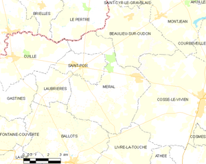
Saint-Poix
- commune in Mayenne, France
- Country:
- Postal Code: 53540
- Coordinates: 47° 57' 55" N, 1° 2' 36" E
- GPS tracks (wikiloc): [Link]
- Area: 7.38 sq km
- Population: 403
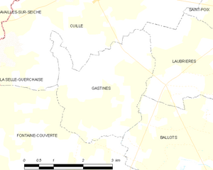
Gastines
- commune in Mayenne, France
- Country:
- Postal Code: 53540
- Coordinates: 47° 57' 7" N, 1° 6' 13" E
- GPS tracks (wikiloc): [Link]
- Area: 8.85 sq km
- Population: 159

Méral
- commune in Mayenne, France
- Country:
- Postal Code: 53230
- Coordinates: 47° 57' 38" N, 0° 58' 50" E
- GPS tracks (wikiloc): [Link]
- Area: 29.5 sq km
- Population: 1084
- Web site: [Link]


Laubrières
- commune in Mayenne, France
- Country:
- Postal Code: 53540
- Coordinates: 47° 56' 30" N, 1° 5' 3" E
- GPS tracks (wikiloc): [Link]
- Area: 8.31 sq km
- Population: 343


Fontaine-Couverte
- commune in Mayenne, France
- Country:
- Postal Code: 53350
- Coordinates: 47° 54' 30" N, 1° 8' 34" E
- GPS tracks (wikiloc): [Link]
- Area: 21.65 sq km
- Population: 437

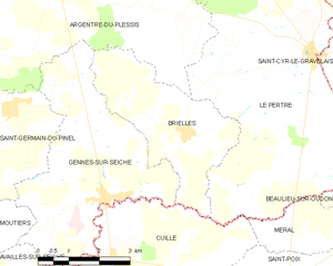
Brielles
- commune in Ille-et-Vilaine, France
- Country:
- Postal Code: 35370
- Coordinates: 48° 0' 31" N, 1° 5' 26" E
- GPS tracks (wikiloc): [Link]
- Area: 11.4 sq km
- Population: 717
- Web site: [Link]


La Selle-Guerchaise
- commune in Ille-et-Vilaine, France
- Country:
- Postal Code: 35130
- Coordinates: 47° 56' 38" N, 1° 10' 22" E
- GPS tracks (wikiloc): [Link]
- Area: 2.14 sq km
- Population: 157

Le Pertre
- commune in Ille-et-Vilaine, France
- Country:
- Postal Code: 35370
- Coordinates: 48° 2' 5" N, 1° 2' 14" E
- GPS tracks (wikiloc): [Link]
- Area: 43.63 sq km
- Population: 1390
- Web site: [Link]


Availles-sur-Seiche
- commune in Ille-et-Vilaine, France
- Country:
- Postal Code: 35130
- Coordinates: 47° 57' 40" N, 1° 11' 45" E
- GPS tracks (wikiloc): [Link]
- Area: 11.06 sq km
- Population: 686