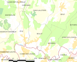
Cussey-sur-l'Ognon (Cussey-sur-l'Ognon)

- commune in Doubs, France
 Hiking in Cussey-sur-l'Ognon
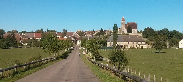
Cussey-sur-l'Ognon is a charming commune located in the department of Doubs in the Bourgogne-Franche-Comté region of France. The area is known for its beautiful natural landscapes, making it a great destination for hiking enthusiasts.
Hiking Trails:
-
Local Trails: Cussey-sur-l'Ognon is surrounded by forested areas and rolling hills, providing several local trails that vary in difficulty and length. You can find paths suitable for casual walkers and more challenging routes for experienced hikers.
-
Ognon River: The trails alongside the Ognon River offer scenic views and a peaceful environment. The riverbanks are perfect for shorter hikes and provide opportunities for birdwatching and enjoying nature.
-
Forest Paths: The nearby forests allow for stunning hikes through lush green scenery. The Bois de Cussey is one such forest, where you can enjoy the tranquility and the chance to observe wildlife.
Tips for Hiking in Cussey-sur-l'Ognon:
- Check Local Maps: Before you set out, be sure to check local hiking maps to find the best trails for your skill level.
- Weather Preparedness: The weather can change quickly, so dress in layers and carry waterproof gear if necessary.
- Stay Hydrated: Bring enough water, especially on warmer days. There may not be any water sources along the trails.
- Safety: Inform someone about your hiking plans, especially if you're hiking alone or in remote areas.
- Leave No Trace: Respect the natural environment by following Leave No Trace principles.
Additional Activities:
In addition to hiking, Cussey-sur-l'Ognon offers opportunities for cycling, fishing, and exploring the local culture and cuisine in nearby towns. The region is also known for its historical sites and beautiful landscapes, perfect for photography and relaxation.
Whether you're looking for a short stroll or a long hike, Cussey-sur-l'Ognon can provide a delightful outdoor experience. Always check local resources for updated trail conditions and recommendations before you go.
- Country:

- Postal Code: 25870
- Coordinates: 47° 20' 20" N, 5° 56' 17" E


- GPS tracks (wikiloc): [Link]
- Area: 7.55 sq km
- Population: 1014
- Web site: http://www.cusseysurlognon.reseaudescommunes.fr/communes/
- Wikipedia en: wiki(en)
- Wikipedia: wiki(fr)
- Wikidata storage: Wikidata: Q836470
- Wikipedia Commons Category: [Link]
- Freebase ID: [/m/03mgsm1]
- Freebase ID: [/m/03mgsm1]
- GeoNames ID: Alt: [6612381]
- GeoNames ID: Alt: [6612381]
- SIREN number: [212501860]
- SIREN number: [212501860]
- BnF ID: [15252412t]
- BnF ID: [15252412t]
- VIAF ID: Alt: [159642266]
- VIAF ID: Alt: [159642266]
- Library of Congress authority ID: Alt: [n2003031633]
- Library of Congress authority ID: Alt: [n2003031633]
- PACTOLS thesaurus ID: [pcrtM15n2bBcFb]
- PACTOLS thesaurus ID: [pcrtM15n2bBcFb]
- INSEE municipality code: 25186
- INSEE municipality code: 25186
Shares border with regions:


Étuz
- commune in Haute-Saône, France
- Country:
- Postal Code: 70150
- Coordinates: 47° 20' 59" N, 5° 56' 23" E
- GPS tracks (wikiloc): [Link]
- Area: 5.3 sq km
- Population: 655


Chambornay-lès-Pin
- commune in Haute-Saône, France
- Country:
- Postal Code: 70150
- Coordinates: 47° 20' 15" N, 5° 54' 25" E
- GPS tracks (wikiloc): [Link]
- Area: 4.85 sq km
- Population: 347

Boulot
- commune in Haute-Saône, France
- Country:
- Postal Code: 70190
- Coordinates: 47° 20' 52" N, 5° 57' 36" E
- GPS tracks (wikiloc): [Link]
- Area: 7.08 sq km
- Population: 670

Bussières, Haute-Saône
- commune in Haute-Saône, France
Hiking in Bussières, Haute-Saône
Bussières, located in the Haute-Saône department in the Bourgogne-Franche-Comté region of France, offers a serene hiking experience that allows you to explore the natural beauty of rural France. While the region is less known than some of the larger national parks, it has its own charm, with varied landscapes including forests, hills, and rivers....
- Country:
- Postal Code: 70190
- Coordinates: 47° 20' 15" N, 5° 58' 27" E
- GPS tracks (wikiloc): [Link]
- Area: 6.11 sq km
- Population: 399


Sauvagney
- commune in Doubs, France
Hiking in Sauvagney
Sauvagney is a small village in the Haute-Saône department in the Bourgogne-Franche-Comté region of eastern France. While it might not be as well-known as some larger hiking destinations, the surrounding countryside offers opportunities for hiking enthusiasts to explore scenic landscapes, forests, and charming rural settings....
- Country:
- Postal Code: 25170
- Coordinates: 47° 19' 25" N, 5° 54' 14" E
- GPS tracks (wikiloc): [Link]
- Area: 3.95 sq km
- Population: 178