Dampsmesnil (Dampsmesnil)

- former commune in Eure, France
- Country:

- Postal Code: 27630
- Coordinates: 49° 10' 3" N, 1° 38' 21" E


- GPS tracks (wikiloc): [Link]
- Area: 5.61 sq km
- Population: 200
- Wikipedia en: wiki(en)
- Wikipedia: wiki(fr)
- Wikidata storage: Wikidata: Q1008538
- Wikipedia Commons Category: [Link]
- Freebase ID: [/m/03nqhhh]
- Freebase ID: [/m/03nqhhh]
- GeoNames ID: Alt: [6430346]
- GeoNames ID: Alt: [6430346]
- BnF ID: [152534362]
- BnF ID: [152534362]
- PACTOLS thesaurus ID: [pcrtqpsK2Zn4tq]
- PACTOLS thesaurus ID: [pcrtqpsK2Zn4tq]
- INSEE municipality code: 27197
- INSEE municipality code: 27197
Shares border with regions:


Bus-Saint-Rémy
- former commune in Eure, France
- Country:
- Postal Code: 27630
- Coordinates: 49° 8' 47" N, 1° 37' 19" E
- GPS tracks (wikiloc): [Link]
- Area: 7.77 sq km
- Population: 314


Montreuil-sur-Epte
- commune in Val-d'Oise, France
- Country:
- Postal Code: 95770
- Coordinates: 49° 10' 35" N, 1° 40' 42" E
- GPS tracks (wikiloc): [Link]
- Area: 7.15 sq km
- Population: 427
- Web site: [Link]


Berthenonville
- former commune in Eure, France
- Country:
- Postal Code: 27630
- Coordinates: 49° 10' 59" N, 1° 39' 41" E
- GPS tracks (wikiloc): [Link]
- Area: 5.92 sq km
- Population: 254

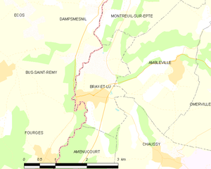
Bray-et-Lû
- commune in Val-d'Oise, France
- Country:
- Postal Code: 95710
- Coordinates: 49° 8' 22" N, 1° 39' 40" E
- GPS tracks (wikiloc): [Link]
- Area: 3.71 sq km
- Population: 950
- Web site: [Link]