Duingt (Duingt)

- commune in Haute-Savoie, France
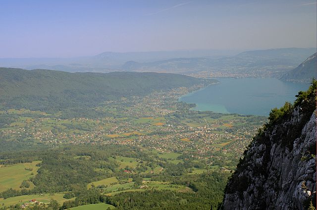
 Hiking in Duingt
Duingt, located in the Haute-Savoie region of France near Lake Annecy, is surrounded by stunning natural landscapes and offers various hiking opportunities for outdoor enthusiasts. Here are some key points about hiking in Duingt:
-
Scenic Views: Hiking in Duingt provides breathtaking views of Lake Annecy and the surrounding mountains, including the Bauges and Aravis ranges. The area is known for its picturesque landscapes, making it a popular destination for photographers and nature lovers.
-
Trail Variety: There are several trails around Duingt suitable for all skill levels. Whether you’re looking for a leisurely stroll or a more challenging hike, you can find routes that fit your preference. Some popular trails include those along the lakeside and up into the surrounding hills.
-
Lac d’Annecy: The area around Lake Annecy features well-maintained paths that are perfect for walking and cycling. The lakeside trail offers an easy hike with stunning views of the water and the mountains.
-
Historical Sites: While hiking, you can also explore historical sites such as the Château de Duingt, a medieval castle that adds cultural enrichment to your outdoor adventure.
-
Seasonal Considerations: The best times for hiking in Duingt are typically spring through early fall, when the weather is mild and the trails are most accessible. Winter hiking is also possible, but it may require additional gear due to snow.
-
Local Tips: It's advisable to check local weather conditions before heading out, as the weather can change rapidly in mountainous areas. Additionally, carrying sufficient water, snacks, and a map or GPS is always a good idea.
-
Environment and Wildlife: Keep an eye out for the rich biodiversity of the region. Various flora and fauna can be spotted, adding an extra layer of enjoyment to your hiking experience.
Whether you're a beginner or an experienced hiker, Duingt and its surrounding areas offer a wonderful place to explore nature and enjoy the beauty of the French Alps. Remember to tread lightly and respect the local environment as you enjoy your hikes!
- Country:

- Postal Code: 74410
- Coordinates: 45° 49' 41" N, 6° 12' 10" E


- GPS tracks (wikiloc): [Link]
- Area: 4.39 sq km
- Population: 939
- Web site: http://www.duingt.fr
- Wikipedia en: wiki(en)
- Wikipedia: wiki(fr)
- Wikidata storage: Wikidata: Q910387
- Wikipedia Commons Category: [Link]
- Freebase ID: [/m/03ntz8w]
- GeoNames ID: Alt: [6442944]
- SIREN number: [217401082]
- BnF ID: [15274366c]
- PACTOLS thesaurus ID: [pcrtaehsm63QOX]
- Twitter username: Alt: [VillageDeDuingt]
- INSEE municipality code: 74108
Shares border with regions:


Entrevernes
- commune in Haute-Savoie, France
Hiking in Entrevernes
Entrevernes is a picturesque commune located in the Auvergne-Rhône-Alpes region of France, nestled at the foot of the majestic French Alps. The area is known for its stunning natural landscapes, making it an excellent destination for hiking enthusiasts of all levels....
- Country:
- Postal Code: 74410
- Coordinates: 45° 47' 43" N, 6° 11' 19" E
- GPS tracks (wikiloc): [Link]
- Area: 8.31 sq km
- Population: 220


Talloires
- former commune in Haute-Savoie, France
Hiking in Talloires
Talloires is a picturesque village located on the shores of Lake Annecy in the French Alps. It offers a variety of hiking opportunities, showcasing stunning views of the lake, mountains, and surrounding countryside. Here are some highlights for hiking in Talloires:...
- Country:
- Postal Code: 74290
- Coordinates: 45° 50' 25" N, 6° 12' 49" E
- GPS tracks (wikiloc): [Link]
- Area: 20.69 sq km
- Population: 1711
- Web site: [Link]


Doussard
- commune in Haute-Savoie, France
Hiking in Doussard
Doussard, located in the Haute-Savoie region of France, is a picturesque town situated on the shores of Lake Annecy, surrounded by stunning alpine scenery. It serves as an excellent base for various outdoor activities, including hiking. Here are some aspects to consider if you're planning a hiking trip in Doussard:...
- Country:
- Postal Code: 74210
- Coordinates: 45° 46' 32" N, 6° 13' 14" E
- GPS tracks (wikiloc): [Link]
- Area: 20.14 sq km
- Population: 3625
- Web site: [Link]


Lathuile
- commune in Haute-Savoie, France
Hiking in Lathuile
Lathuile is a charming village located in the Annecy region of the French Alps, known for its stunning landscapes and outdoor activities, including hiking. It’s nestled near the shores of Lake Annecy, one of the cleanest lakes in Europe, providing a beautiful backdrop for hiking adventures....
- Country:
- Postal Code: 74210
- Coordinates: 45° 46' 57" N, 6° 12' 10" E
- GPS tracks (wikiloc): [Link]
- Area: 8.76 sq km
- Population: 1041
- Web site: [Link]

Saint-Jorioz
- commune in Haute-Savoie, France
Hiking in Saint-Jorioz
Saint-Jorioz is a beautiful commune located on the shores of Lake Annecy in the Haute-Savoie region of France. Surrounded by stunning natural landscapes, it offers a variety of hiking opportunities for outdoor enthusiasts. Here’s an overview of what you can expect when hiking in and around Saint-Jorioz:...
- Country:
- Postal Code: 74410
- Coordinates: 45° 50' 1" N, 6° 9' 50" E
- GPS tracks (wikiloc): [Link]
- Area: 21.12 sq km
- Population: 5747
- Web site: [Link]