Ennezat (Ennezat)

- commune in Puy-de-Dôme, France
- Country:

- Postal Code: 63720
- Coordinates: 45° 53' 52" N, 3° 13' 25" E


- GPS tracks (wikiloc): [Link]
- Area: 18.31 sq km
- Population: 2518
- Wikipedia en: wiki(en)
- Wikipedia: wiki(fr)
- Wikidata storage: Wikidata: Q333441
- Wikipedia Commons Category: [Link]
- Freebase ID: [/m/03qh9wz]
- GeoNames ID: Alt: [3020164]
- SIREN number: [216301481]
- BnF ID: [152694988]
- VIAF ID: Alt: [240555855]
- PACTOLS thesaurus ID: [pcrtfESOljzTAN]
- WOEID: [589674]
- INSEE municipality code: 63148
Shares border with regions:

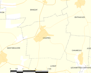
Chappes
- commune in Puy-de-Dôme, France
- Country:
- Postal Code: 63720
- Coordinates: 45° 52' 7" N, 3° 13' 14" E
- GPS tracks (wikiloc): [Link]
- Area: 10.21 sq km
- Population: 1665


Saint-Beauzire
- commune in Puy-de-Dôme, France
- Country:
- Postal Code: 63360
- Coordinates: 45° 50' 59" N, 3° 10' 46" E
- GPS tracks (wikiloc): [Link]
- Area: 16.08 sq km
- Population: 2102
- Web site: [Link]
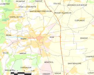
Riom
- commune in Puy-de-Dôme, France
- Country:
- Postal Code: 63200
- Coordinates: 45° 53' 37" N, 3° 6' 45" E
- GPS tracks (wikiloc): [Link]
- AboveSeaLevel: 337 м m
- Area: 31.97 sq km
- Population: 18987
- Web site: [Link]
Saint-Ignat
- commune in Puy-de-Dôme, France
- Country:
- Postal Code: 63720
- Coordinates: 45° 55' 23" N, 3° 16' 28" E
- GPS tracks (wikiloc): [Link]
- Area: 15.37 sq km
- Population: 857
- Web site: [Link]
Clerlande
- commune in Puy-de-Dôme, France
- Country:
- Postal Code: 63720
- Coordinates: 45° 55' 6" N, 3° 11' 29" E
- GPS tracks (wikiloc): [Link]
- Area: 8.31 sq km
- Population: 540


Entraigues
- commune in Puy-de-Dôme, France
- Country:
- Postal Code: 63720
- Coordinates: 45° 53' 24" N, 3° 15' 39" E
- GPS tracks (wikiloc): [Link]
- Area: 9.72 sq km
- Population: 644


Martres-sur-Morge
- commune in Puy-de-Dôme, France
- Country:
- Postal Code: 63720
- Coordinates: 45° 56' 13" N, 3° 13' 13" E
- GPS tracks (wikiloc): [Link]
- Area: 8.22 sq km
- Population: 656
- Web site: [Link]