Famechon (Famechon)

- commune in Somme, France
- Country:

- Postal Code: 80290
- Coordinates: 49° 45' 37" N, 2° 2' 27" E


- GPS tracks (wikiloc): [Link]
- Area: 4.84 sq km
- Population: 253
- Wikipedia en: wiki(en)
- Wikipedia: wiki(fr)
- Wikidata storage: Wikidata: Q121518
- Wikipedia Commons Category: [Link]
- Freebase ID: [/m/03gyh21]
- GeoNames ID: Alt: [6444427]
- SIREN number: [218002889]
- BnF ID: [152767826]
- INSEE municipality code: 80301
Shares border with regions:

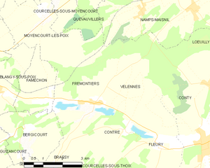
Frémontiers
- commune in Somme, France
- Country:
- Postal Code: 80160
- Coordinates: 49° 45' 33" N, 2° 4' 28" E
- GPS tracks (wikiloc): [Link]
- Area: 12.89 sq km
- Population: 153
- Web site: [Link]

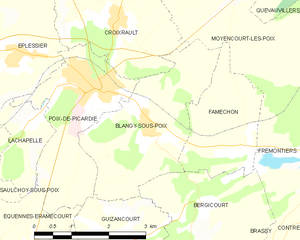
Blangy-sous-Poix
- commune in Somme, France
- Country:
- Postal Code: 80290
- Coordinates: 49° 46' 0" N, 2° 0' 8" E
- GPS tracks (wikiloc): [Link]
- Area: 8.01 sq km
- Population: 187


Moyencourt-lès-Poix
- commune in Somme, France
- Country:
- Postal Code: 80290
- Coordinates: 49° 48' 10" N, 2° 2' 6" E
- GPS tracks (wikiloc): [Link]
- Area: 10.45 sq km
- Population: 176

Bergicourt
- commune in Somme, France
- Country:
- Postal Code: 80290
- Coordinates: 49° 44' 50" N, 2° 1' 26" E
- GPS tracks (wikiloc): [Link]
- Area: 6.85 sq km
- Population: 156