Faverelles (Faverelles)

- commune in Loiret, France
- Country:

- Postal Code: 45420
- Coordinates: 47° 34' 31" N, 2° 55' 51" E


- GPS tracks (wikiloc): [Link]
- Area: 18.92 sq km
- Population: 152
- Wikipedia en: wiki(en)
- Wikipedia: wiki(fr)
- Wikidata storage: Wikidata: Q976306
- Wikipedia Commons Category: [Link]
- Freebase ID: [/m/03nwh3g]
- GeoNames ID: Alt: [6434597]
- SIREN number: [214501413]
- BnF ID: [15260533s]
- INSEE municipality code: 45141
Shares border with regions:


Batilly-en-Puisaye
- commune in Loiret, France
- Country:
- Postal Code: 45420
- Coordinates: 47° 36' 44" N, 2° 53' 0" E
- GPS tracks (wikiloc): [Link]
- AboveSeaLevel: 200 м m
- Area: 17.35 sq km
- Population: 114

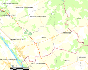
Thou
- commune in Loiret, France
- Country:
- Postal Code: 45420
- Coordinates: 47° 34' 49" N, 2° 54' 30" E
- GPS tracks (wikiloc): [Link]
- Area: 15.16 sq km
- Population: 238
- Web site: [Link]


Lavau
- commune in Yonne, France
- Country:
- Postal Code: 89170
- Coordinates: 47° 35' 44" N, 2° 59' 14" E
- GPS tracks (wikiloc): [Link]
- Area: 55.06 sq km
- Population: 475

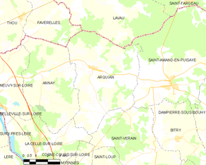
Arquian
- commune in Nièvre, France
- Country:
- Postal Code: 58310
- Coordinates: 47° 32' 30" N, 2° 59' 18" E
- GPS tracks (wikiloc): [Link]
- Area: 33.56 sq km
- Population: 590


Annay
- commune in Nièvre, France
- Country:
- Postal Code: 58450
- Coordinates: 47° 32' 9" N, 2° 55' 58" E
- GPS tracks (wikiloc): [Link]
- Area: 26.27 sq km
- Population: 340