Fescamps (Fescamps)

- commune in Somme, France
- Country:

- Postal Code: 80500
- Coordinates: 49° 38' 24" N, 2° 40' 59" E


- GPS tracks (wikiloc): [Link]
- Area: 5.08 sq km
- Population: 144
- Wikipedia en: wiki(en)
- Wikipedia: wiki(fr)
- Wikidata storage: Wikidata: Q120807
- Wikipedia Commons Category: [Link]
- Freebase ID: [/m/03nr713]
- GeoNames ID: Alt: [6444429]
- SIREN number: [218002939]
- BnF ID: [15276787x]
- INSEE municipality code: 80306
Shares border with regions:


Bus-la-Mésière
- commune in Somme, France
- Country:
- Postal Code: 80700
- Coordinates: 49° 38' 12" N, 2° 42' 55" E
- GPS tracks (wikiloc): [Link]
- Area: 6.85 sq km
- Population: 173


Boulogne-la-Grasse
- commune in Oise, France
- Country:
- Postal Code: 60490
- Coordinates: 49° 36' 40" N, 2° 42' 17" E
- GPS tracks (wikiloc): [Link]
- Area: 9.41 sq km
- Population: 480

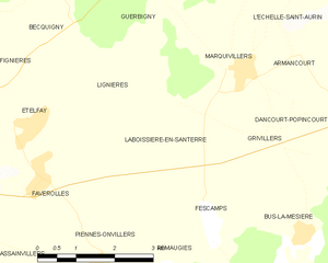
Laboissière-en-Santerre
- commune in Somme, France
- Country:
- Postal Code: 80500
- Coordinates: 49° 39' 57" N, 2° 40' 39" E
- GPS tracks (wikiloc): [Link]
- Area: 7.15 sq km
- Population: 162


Grivillers
- commune in Somme, France
- Country:
- Postal Code: 80700
- Coordinates: 49° 39' 41" N, 2° 42' 26" E
- GPS tracks (wikiloc): [Link]
- Area: 3.39 sq km
- Population: 80


Piennes-Onvillers
- commune in Somme, France
- Country:
- Postal Code: 80500
- Coordinates: 49° 37' 36" N, 2° 38' 29" E
- GPS tracks (wikiloc): [Link]
- AboveSeaLevel: 104 м m
- Area: 12.29 sq km
- Population: 366
- Web site: [Link]


Remaugies
- commune in Somme, France
- Country:
- Postal Code: 80500
- Coordinates: 49° 37' 40" N, 2° 39' 59" E
- GPS tracks (wikiloc): [Link]
- Area: 4.14 sq km
- Population: 128