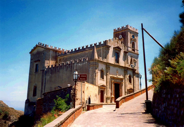
Forza d'Agrò (Forza d'Agrò)
.svg)
- Italian comune
 Hiking in Forza d'Agrò
Forza d'Agrò is a charming hilltop village located in Sicily, Italy, known for its stunning views, historical sites, and scenic hiking opportunities. Nestled in the foothills of the Peloritani Mountains, it offers a variety of trails suitable for different skill levels, making it ideal for both novice and experienced hikers.
Hiking Highlights in Forza d'Agrò:
-
Scenic Views: Many trails offer breathtaking views of the surrounding landscape, including the coastline of Taormina and Mount Etna. The panoramic vistas provide excellent photo opportunities, especially during sunrise and sunset.
-
Historical Trails: Hikers can explore routes that take them past ancient ruins and historical landmarks. The village itself has significant historical architecture, and the surrounding areas are dotted with remnants of old forts and churches.
-
Nature Trails: The region is rich in biodiversity, allowing hikers to enjoy lush landscapes, Mediterranean vegetation, and wildlife. Trails through mountainous terrain provide a chance to experience the natural beauty of Sicily.
-
Cultural Integration: Hiking in Forza d'Agrò also allows for cultural immersion. You can stop at local eateries or agriturismos to taste traditional Sicilian cuisine, including local wines and freshly made dishes.
-
Trail Recommendations:
- Forza d'Agrò to Savoca: This is a popular route that connects Forza d'Agrò with the nearby village of Savoca, famous for its role in "The Godfather." The trail is moderate, offering both cultural and natural sights.
- Discovering the Ruins: Various paths lead to old ruins scattered throughout the hills, where you can experience the rich history of the area.
- Nature Walks in Nearby Parks: Exploring nearby nature reserves and parks is also a good option for those looking for well-marked trails and more extended hikes.
-
Weather Considerations: The best time to hike in Forza d'Agrò is during the spring (April to June) and fall (September to October) when the temperatures are mild. Summer can be quite hot, and winter may bring cooler temperatures, especially at higher elevations.
-
Preparation Tips:
- Wear sturdy hiking shoes for rocky terrain.
- Carry plenty of water and snacks, especially on longer hikes.
- Make sure to have a map or a reliable GPS device, as some trails may not be well-marked.
Forza d'Agrò offers a unique combination of cultural, historical, and natural attractions that can enrich your hiking experience. Whether you're looking for a relaxing stroll or a challenging trek, the area has something for everyone!
- Country:

- Postal Code: 98030
- Local Dialing Code: 0942
- Licence Plate Code: ME
- Coordinates: 37° 54' 53" N, 15° 20' 3" E


- GPS tracks (wikiloc): [Link]
- AboveSeaLevel: 420 м m
- Area: 11.19 sq km
- Population: 898
- Web site: http://www.comune.forzadagro.me.it/
- Wikipedia en: wiki(en)
- Wikipedia: wiki(it)
- Wikidata storage: Wikidata: Q496120
- Wikipedia Commons Gallery: [Link]
- Wikipedia Commons Category: [Link]
- Freebase ID: [/m/0ff5lx]
- GeoNames ID: Alt: [6537759]
- VIAF ID: Alt: [243220699]
- OSM relation ID: [39416]
- GND ID: Alt: [7551813-2]
- WOEID: [715725]
- ISTAT ID: 083024
- Italian cadastre code: D733
Shares border with regions:
Gallodoro
- Italian comune
Hiking in Gallodoro
Gallodoro is a small village located in the province of Messina, Sicily, Italy. Nestled in the Nebrodi Mountains, it offers beautiful landscapes and a variety of hiking opportunities for enthusiasts of all levels. Here are some details to help you plan your hiking adventure in Gallodoro:...
- Country:
- Postal Code: 98030
- Local Dialing Code: 0942
- Licence Plate Code: ME
- Coordinates: 37° 54' 6" N, 15° 17' 36" E
- GPS tracks (wikiloc): [Link]
- AboveSeaLevel: 388 м m
- Area: 6.91 sq km
- Population: 363
- Web site: [Link]
Mongiuffi Melia
- Italian comune
Hiking in Mongiuffi Melia
Mongiuffi Melia is a charming village located in the province of Messina, Sicily, Italy. It's surrounded by stunning natural landscapes, making it a wonderful destination for hiking enthusiasts. Here are some highlights about hiking in and around Mongiuffi Melia:...
- Country:
- Postal Code: 98030
- Local Dialing Code: 0942
- Licence Plate Code: ME
- Coordinates: 37° 54' 0" N, 15° 16' 0" E
- GPS tracks (wikiloc): [Link]
- AboveSeaLevel: 421 м m
- Area: 24.36 sq km
- Population: 578
- Web site: [Link]


Sant'Alessio Siculo
- Italian comune
Hiking in Sant'Alessio Siculo
Sant'Alessio Siculo is a picturesque coastal village located in Sicily, Italy, nestled between the stunning backdrop of the Peloritani Mountains and the Ionian Sea. Hiking in this area offers a wonderful combination of beautiful natural landscapes, coastal views, and opportunities to explore charming Sicilian culture....
- Country:
- Postal Code: 98030
- Local Dialing Code: 0942
- Licence Plate Code: ME
- Coordinates: 37° 55' 18" N, 15° 20' 49" E
- GPS tracks (wikiloc): [Link]
- AboveSeaLevel: 15 м m
- Area: 6.17 sq km
- Population: 1520
- Web site: [Link]


Casalvecchio Siculo
- Italian comune
Hiking in Casalvecchio Siculo
Casalvecchio Siculo is a charming village located in the province of Messina, Sicily, Italy. Nestled in the hills with stunning views of the coastline and the surrounding landscape, it's an excellent destination for hiking enthusiasts who wish to explore the Sicilian countryside....
- Country:
- Postal Code: 98032
- Local Dialing Code: 0942
- Licence Plate Code: ME
- Coordinates: 37° 57' 27" N, 15° 19' 19" E
- GPS tracks (wikiloc): [Link]
- AboveSeaLevel: 370 м m
- Area: 33.62 sq km
- Population: 796
- Web site: [Link]


Limina
- Italian comune
Hiking in Limina
Limina is a small village located in the Province of Messina, Sicily, Italy. It’s surrounded by beautiful landscapes, making it an intriguing destination for hiking enthusiasts. The area features rolling hills, dense forests, and views of the surrounding mountains, all of which provide varied terrain for hikers of all experience levels....
- Country:
- Postal Code: 98030
- Local Dialing Code: 0942
- Licence Plate Code: ME
- Coordinates: 37° 57' 0" N, 15° 16' 0" E
- GPS tracks (wikiloc): [Link]
- AboveSeaLevel: 510 м m
- Area: 9.99 sq km
- Population: 809
- Web site: [Link]


Letojanni
- Italian comune
Hiking in Letojanni
Letojanni, a charming coastal town in Sicily, Italy, offers a variety of hiking opportunities that take advantage of its stunning natural landscapes, including mountains, cliffs, and the beautiful coastline along the Ionian Sea. Here are some key points to consider when hiking in Letojanni:...
- Country:
- Postal Code: 98037
- Local Dialing Code: 0942
- Licence Plate Code: ME
- Coordinates: 37° 53' 0" N, 15° 18' 0" E
- GPS tracks (wikiloc): [Link]
- AboveSeaLevel: 5 м m
- Area: 6.72 sq km
- Population: 2831
- Web site: [Link]

Savoca
- Italian comune
Hiking in Savoca
Savoca is a picturesque village located in Sicily, Italy, known for its charming medieval architecture and stunning views of the surrounding landscape. Hiking in and around Savoca offers a unique blend of natural beauty, historical sites, and cultural experiences. Here are some highlights and tips for hiking in the area:...
- Country:
- Postal Code: 98038
- Local Dialing Code: 0942
- Licence Plate Code: ME
- Coordinates: 37° 57' 21" N, 15° 20' 23" E
- GPS tracks (wikiloc): [Link]
- AboveSeaLevel: 330 м m
- Area: 9.08 sq km
- Population: 1715
- Web site: [Link]