Freudenstadt VVG (Vereinbarte Verwaltungsgemeinschaft Freudenstadt)
- agreed administrative community in the district Landkreis Freudenstadt, Baden-Württemberg, Germany
 Hiking in Freudenstadt VVG
Freudenstadt, located in the northern part of the Black Forest region of Germany, offers a beautiful setting for hiking enthusiasts. It's particularly known for its vast forests, stunning landscapes, and well-marked trails that cater to various skill levels. Here's some information to help guide your hiking experience in the Freudenstadt area:
Trails and Areas to Explore
-
Panorama Trail: This is one of the most popular hiking routes. It showcases stunning views of the surrounding Black Forest and the valleys below. The trail is well-marked and suitable for moderate hikers.
-
Lothar Trail: Named after the storm that affected the Black Forest, this trail takes you through areas showing signs of nature's regeneration. It offers insights into ecology, as well as beautiful scenery.
-
Hochkopf Circuit: This is a higher-altitude hike that provides panoramic views and a chance to see some unique flora and fauna. The trail begins in Freudenstadt and leads through picturesque landscapes.
-
Mummelsee Circular Trail: Starting from the Mummelsee lake, this circular route offers a moderate hike with the opportunity to enjoy the serene beauty of the lake and surrounding mountains.
Practical Tips
-
Maps and Navigation: Make sure to have a detailed map or use a hiking app, as there can be numerous trails that might not be well-signed.
-
Weather Preparedness: The weather in the Black Forest can change rapidly. It's wise to check forecasts before heading out and dress in layers.
-
Equipment: Good hiking boots are essential due to varying terrain, and a trekking pole can be useful on steeper sections. Carry enough water and snacks for the duration of your hike.
-
Leave No Trace: As with any natural area, remember to pack out what you bring in to help preserve the beauty of the Black Forest.
Additional Attractions
After a rewarding hike, you can explore the town of Freudenstadt itself, known for its historical market square, which is one of the largest in Germany, and its nearby wellness facilities.
Overall, Freudenstadt provides an excellent base for hiking adventures in the Black Forest, with a variety of trail options and breathtaking natural beauty. Enjoy your hiking experience!
- Country:

- Wikidata storage: Wikidata: Q11838010
- OSM relation ID: [2953248]
- German regional key: 082375002
Includes regions:

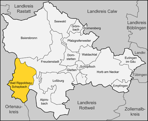
Bad Rippoldsau-Schapbach
- municipality in Germany
Hiking in Bad Rippoldsau-Schapbach
Bad Rippoldsau-Schapbach is a picturesque municipality located in the Black Forest region of Germany, renowned for its stunning landscapes, rich nature, and a variety of hiking trails suitable for all skill levels. Here are some highlights you can expect when hiking in this area:...
- Country:
- Postal Code: 77776
- Local Dialing Code: 07839; 07440
- Coordinates: 48° 22' 38" N, 8° 17' 31" E


- GPS tracks (wikiloc): [Link]
- AboveSeaLevel: 410 м m
- Area: 73.14 sq km
- Population: 2149
- Web site: [Link]


Seewald
- municipality in Germany
Hiking in Seewald
Seewald is a picturesque village located in the Black Forest region of Germany, known for its beautiful landscapes, lush forests, and serene trails. Here are some key aspects of hiking in and around Seewald:...
- Country:
- Postal Code: 72297
- Local Dialing Code: 07447
- Licence Plate Code: FDS
- Coordinates: 48° 35' 38" N, 8° 25' 15" E
- GPS tracks (wikiloc): [Link]
- AboveSeaLevel: 782 м m
- Area: 58.5 sq km
- Population: 2142
- Web site: [Link]


Freudenstadt
- municipality in Germany
Hiking in Freudenstadt
Freudenstadt, located in the Black Forest region of Germany, is a fantastic destination for hiking enthusiasts. The town is renowned for its stunning landscapes, deep forests, and well-marked trails that cater to a variety of skill levels. Here are some highlights:...
- Country:
- Postal Code: 72250
- Local Dialing Code: 07443; 07442; 07441
- Licence Plate Code: FDS
- Coordinates: 48° 27' 48" N, 8° 24' 40" E
- GPS tracks (wikiloc): [Link]
- AboveSeaLevel: 728 м m
- Area: 87.58 sq km
- Population: 23150
- Web site: [Link]