Froidfond (Froidfond)

- commune in Vendée, France
- Country:

- Postal Code: 85300
- Coordinates: 46° 52' 8" N, 1° 45' 27" E


- GPS tracks (wikiloc): [Link]
- Area: 21.51 sq km
- Population: 1785
- Web site: http://www.froidfond.fr/
- Wikipedia en: wiki(en)
- Wikipedia: wiki(fr)
- Wikidata storage: Wikidata: Q965578
- Wikipedia Commons Category: [Link]
- Freebase ID: [/m/03qltl5]
- GeoNames ID: Alt: [3017003]
- SIREN number: [218500957]
- BnF ID: [152782213]
- INSEE municipality code: 85095
Shares border with regions:


Touvois
- commune in Loire-Atlantique, France
- Country:
- Postal Code: 44650
- Coordinates: 46° 54' 10" N, 1° 40' 59" E
- GPS tracks (wikiloc): [Link]
- Area: 39.21 sq km
- Population: 1770


Falleron
- commune in Vendée, France
- Country:
- Postal Code: 85670
- Coordinates: 46° 52' 56" N, 1° 42' 14" E
- GPS tracks (wikiloc): [Link]
- Area: 28.64 sq km
- Population: 1553
- Web site: [Link]

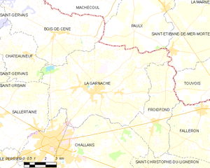
La Garnache
- commune in Vendée, France
- Country:
- Postal Code: 85710
- Coordinates: 46° 53' 26" N, 1° 49' 52" E
- GPS tracks (wikiloc): [Link]
- Area: 59.49 sq km
- Population: 4859
- Web site: [Link]

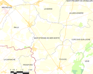
Saint-Étienne-de-Mer-Morte
- commune in Loire-Atlantique, France
- Country:
- Postal Code: 44270
- Coordinates: 46° 55' 47" N, 1° 44' 34" E
- GPS tracks (wikiloc): [Link]
- Area: 27.33 sq km
- Population: 1680


Challans
- commune in Vendée, France
- Country:
- Postal Code: 85300
- Coordinates: 46° 50' 45" N, 1° 52' 45" E
- GPS tracks (wikiloc): [Link]
- Area: 64.84 sq km
- Population: 20133
- Web site: [Link]


Saint-Christophe-du-Ligneron
- commune in Vendée, France
- Country:
- Postal Code: 85670
- Coordinates: 46° 49' 27" N, 1° 45' 47" E
- GPS tracks (wikiloc): [Link]
- Area: 42.42 sq km
- Population: 2531
- Web site: [Link]