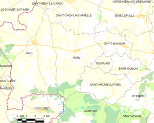
Gaël (Gaël)

- commune in Ille-et-Vilaine, France
- Country:

- Postal Code: 35290
- Coordinates: 48° 7' 56" N, 2° 13' 17" E


- GPS tracks (wikiloc): [Link]
- Area: 52.1 sq km
- Population: 1667
- Web site: http://www.mairie-gael.fr
- Wikipedia en: wiki(en)
- Wikipedia: wiki(fr)
- Wikidata storage: Wikidata: Q216544
- Wikipedia Commons Category: [Link]
- Freebase ID: [/m/06hfsz]
- Freebase ID: [/m/06hfsz]
- Freebase ID: [/m/06hfsz]
- GeoNames ID: Alt: [6432703]
- GeoNames ID: Alt: [6432703]
- GeoNames ID: Alt: [6432703]
- SIREN number: [213501174]
- SIREN number: [213501174]
- SIREN number: [213501174]
- BnF ID: [152570614]
- BnF ID: [152570614]
- BnF ID: [152570614]
- OSM relation ID: [531019]
- OSM relation ID: [531019]
- OSM relation ID: [531019]
- PACTOLS thesaurus ID: [pcrtsrkqn7dSyS]
- PACTOLS thesaurus ID: [pcrtsrkqn7dSyS]
- PACTOLS thesaurus ID: [pcrtsrkqn7dSyS]
- INSEE municipality code: 35117
- INSEE municipality code: 35117
- INSEE municipality code: 35117
Shares border with regions:


Saint-Léry
- commune in Morbihan, France
- Country:
- Postal Code: 56430
- Coordinates: 48° 5' 24" N, 2° 15' 22" E
- GPS tracks (wikiloc): [Link]
- Area: 1.58 sq km
- Population: 189

Muel
- commune in Ille-et-Vilaine, France
- Country:
- Postal Code: 35290
- Coordinates: 48° 7' 38" N, 2° 9' 26" E
- GPS tracks (wikiloc): [Link]
- AboveSeaLevel: 67 м m
- Area: 28.9 sq km
- Population: 905
- Web site: [Link]


Saint-Onen-la-Chapelle
- commune in Ille-et-Vilaine, France
- Country:
- Postal Code: 35290
- Coordinates: 48° 10' 37" N, 2° 10' 22" E
- GPS tracks (wikiloc): [Link]
- Area: 24.66 sq km
- Population: 1191
- Web site: [Link]


Saint-Méen-le-Grand
- commune in Ille-et-Vilaine, France
- Country:
- Postal Code: 35290
- Coordinates: 48° 11' 21" N, 2° 11' 27" E
- GPS tracks (wikiloc): [Link]
- Area: 18.28 sq km
- Population: 4610
- Web site: [Link]


Mauron
- commune in Morbihan, France
- Country:
- Postal Code: 56430
- Coordinates: 48° 4' 56" N, 2° 17' 9" E
- GPS tracks (wikiloc): [Link]
- Area: 67.23 sq km
- Population: 3105
- Web site: [Link]

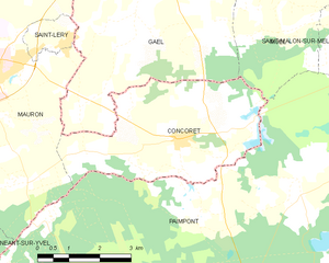
Concoret
- commune in Morbihan, France
- Country:
- Postal Code: 56430
- Coordinates: 48° 3' 51" N, 2° 12' 23" E
- GPS tracks (wikiloc): [Link]
- Area: 15.76 sq km
- Population: 735


Loscouët-sur-Meu
- commune in Côtes-d'Armor, France
- Country:
- Postal Code: 22230
- Coordinates: 48° 10' 40" N, 2° 14' 31" E
- GPS tracks (wikiloc): [Link]
- Area: 22.26 sq km
- Population: 646

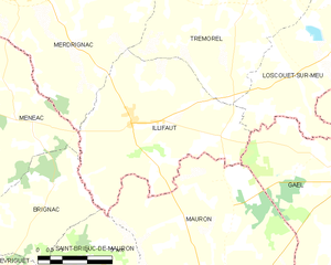
Illifaut
- commune in Côtes-d'Armor, France
- Country:
- Postal Code: 22230
- Coordinates: 48° 8' 46" N, 2° 20' 54" E
- GPS tracks (wikiloc): [Link]
- Area: 26.71 sq km
- Population: 710